IMAGES TAKEN NEAR TO
Chapel Lane, HALESOWEN, B62 0NG
Introduction
This page details the photographs taken nearby to Chapel Lane, B62 0NG by members of the Geograph project.
The Geograph project started in 2005 with the aim of publishing, organising and preserving representative images for every square kilometre of Great Britain, Ireland and the Isle of Man.

There are currently over 7.5m images from over14,400 individuals and you can help contribute to the project by visiting https://www.geograph.org.uk
Image Map
Images are licensed for reuse under creativecommons.org/licenses/by-sa/2.0
Notes
- Clicking on the map will re-center to the selected point.
- The higher the marker number, the further away the image location is from the centre of the postcode.
Image Listing (47 Images Found)
Images are licensed for reuse under creativecommons.org/licenses/by-sa/2.0
Image
Details
Distance
1

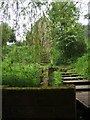
St Kenelm's Spring, Clent
Behind St Kenelm's church in the Clent Hills is a spring and well near where Kenelm, a Mercia king was allegedly murdered around 820AD. Image]
'Now, take St Kenelm's life which I've been reading;
He was Kenulph's son, the nobel king
Of Mercia. Now St Kenelm dreamt a thing
Shortly before they murdered him one day.
He saw his murder in a dream, I say...'
- Chaucer, The Nun's Priest's Tale
Image: © Philip Halling
Taken: 27 Jan 2008
0.01 miles
2
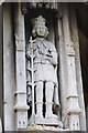
Carving on the lychgate
Carving, presumably of St Kenelm, above the entrance of the lychgate to Romsley church.
Image: © Philip Halling
Taken: 5 Apr 2018
0.01 miles
3
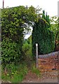
Public footpath by St Kenelm's Church
This is the start of the public footpath which, for a short distance, runs alongside one of the boundaries of the church grounds.
Image
Image: © P L Chadwick
Taken: 22 Aug 2010
0.01 miles
4
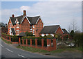
Chapel Farm, St Kenelm's Road
The new garage has the same date motif in the bricks as the original building
Image: © Geoff Gartside
Taken: 7 Apr 2007
0.02 miles
5
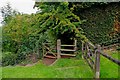
Gate from church grounds onto public footpath
The gate near the centre of the photograph, leads from the grounds of St. Kenelm's Church onto a public footpath.
Image
Image: © P L Chadwick
Taken: 22 Aug 2010
0.02 miles
6

Plaque by St Kenelm's Spring
Information plaque beside St Kenelm's Spring. Image]
Image: © Philip Halling
Taken: 27 Jan 2008
0.02 miles
7
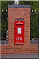
Edward VII Post Box
Adjacent to St Kenelm's Church
Image: © Geoff Gartside
Taken: 7 Apr 2007
0.02 miles
8
St Kenelm's Spring and Church
The source of the River Stour is immediately below the church on the Clent Hills.
Image: © John M
Taken: 18 May 2008
0.02 miles
9
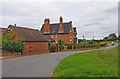
Chapel Farm and a tale of two postboxes
Apart from the adjacent Church of St. Kenelm, the farm is the only building in the immediate neighbourhood. The house is dated 1868. There used to be a village here called Kennelmstowe, long ago, but that has disappeared. Possibly it was a victim of the 14th century Black Death, or maybe there was another cause.
In this view you can just make out two red postboxes. One is set into the wall of a farm outbuilding, the other, to the right of the picture, is at the entrance drive to the farm. Only one of these is operated by Royal Mail, so anyone posting a letter needs to make the correct choice! See why:- Image
Image: © P L Chadwick
Taken: 22 Aug 2010
0.02 miles
10
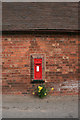
Don't post your letter here!
It looks like a Royal Mail postbox, and anyone not local and in a hurry might well post their mail here. But this is actually a mailbox for Chapel Farm, and is set into the wall of the entrance drive. It may be a genuine original sold off as surplus to requirements, or it could be a replica, as several companies manufacture and sell these for private use. The design is one used during the reign of George V (1910-1936). There is a notice saying post for Chapel Farm only and also a no collections sign!
There is an official Royal Mail postbox nearby, near St. Kenelm's Church. See:- Image
Image
Image: © P L Chadwick
Taken: 22 Aug 2010
0.02 miles