IMAGES TAKEN NEAR TO
Cliff Rock Road, BIRMINGHAM, B45 8QJ
Introduction
This page details the photographs taken nearby to Cliff Rock Road, B45 8QJ by members of the Geograph project.
The Geograph project started in 2005 with the aim of publishing, organising and preserving representative images for every square kilometre of Great Britain, Ireland and the Isle of Man.

There are currently over 7.5m images from over14,400 individuals and you can help contribute to the project by visiting https://www.geograph.org.uk
Image Map
Images are licensed for reuse under creativecommons.org/licenses/by-sa/2.0
Notes
- Clicking on the map will re-center to the selected point.
- The higher the marker number, the further away the image location is from the centre of the postcode.
Image Listing (14 Images Found)
Images are licensed for reuse under creativecommons.org/licenses/by-sa/2.0
Image
Details
Distance
3
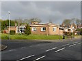
Rednal Library
This rather unusual Arts and Crafts building dates from 1909, when it was built by Benjamin Bower as the local library. It attracted a Grade II listing https://britishlistedbuildings.co.uk/101343066-rednal-library-longbridge-ward#.ZATBBHbP3IU & https://historicengland.org.uk/listing/the-list/list-entry/1343066 in 1982. A quick peer through the windows suggests it's no longer a library, but appeared to be some sort of council store for office equipment, maybe, and no longer open to the public.
Image: © Richard Law
Taken: 10 Aug 2022
0.12 miles
4
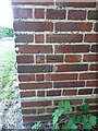
OS benchmark - Rubery, Rednal Library
Located on the south face of Image, this mark was verified by the OS in 1956 at 211.595m above Ordnance Datum Newlyn.
Image: © Richard Law
Taken: 10 Aug 2022
0.13 miles
8
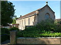
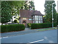
The Catholic Church of Our Lady of Perpetual Succour
A Catholic church just off Leach Heath Lane in Rubery.
Image: © Richard Law
Taken: 10 Aug 2022
0.18 miles
10

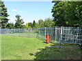
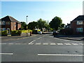
Say please
Possibly only in the UK would a sign indicating prohibited activity say "please". Photographed at the intersection of Bristol Road South (A38) and Park Way.
Image: © Peter Whatley
Taken: 10 Mar 2012
0.22 miles