IMAGES TAKEN NEAR TO
Hackett Street, BIRMINGHAM, B45 8FT
Introduction
This page details the photographs taken nearby to Hackett Street, B45 8FT by members of the Geograph project.
The Geograph project started in 2005 with the aim of publishing, organising and preserving representative images for every square kilometre of Great Britain, Ireland and the Isle of Man.

There are currently over 7.5m images from over14,400 individuals and you can help contribute to the project by visiting https://www.geograph.org.uk
Image Map
Images are licensed for reuse under creativecommons.org/licenses/by-sa/2.0
Notes
- Clicking on the map will re-center to the selected point.
- The higher the marker number, the further away the image location is from the centre of the postcode.
Image Listing (11 Images Found)
Images are licensed for reuse under creativecommons.org/licenses/by-sa/2.0
Image
Details
Distance
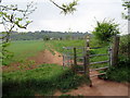
1
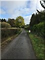
Access to new Housing off Cofton Church Lane
A new housing estate has been built on the southernmost part of the Longbridge works. This path links the church and Cofton Church Lane to the estate.
Image: © Paul Collins
Taken: 2 May 2021
0.09 miles
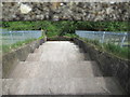
2
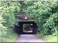
Cofton Hackett, Birmingham to Bristol Main Line Railway Bridge
The main line crosses the narrow Cofton Church Lane just South of the end of the old Austin Rover works.
Image: © Roy Hughes
Taken: 20 Jun 2011
0.13 miles
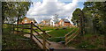
5
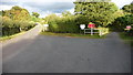
End of the road.
Off to the left private track to Cofton Richards Farm whilst track to the right leads to the sailing club on the reservoir.
Image: © Mike Dodman
Taken: 22 Sep 2009
0.22 miles
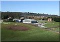
7
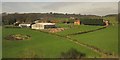
Cofton Hall Farm
Like Image, this was taken from the main railway line between Longbridge and Barnt Green. The farm and its buildings constitutes a hamlet in its own right. The prominent barn has been added since the version of Google Maps I was using. The farmhouse is behind this barn. Tucked behind are a listed C18 barn, stables and cow house http://list.english-heritage.org.uk/resultsingle.aspx?uid=1100212&searchtype=mapsearch . On the right are two cottages. In the background is the wooded Cofton Hill, part of the Lickey Hills.
Image: © Derek Harper
Taken: 6 Apr 2012
0.24 miles