IMAGES TAKEN NEAR TO
Broomcroft Road, BIRMINGHAM, B37 6HJ
Introduction
This page details the photographs taken nearby to Broomcroft Road, B37 6HJ by members of the Geograph project.
The Geograph project started in 2005 with the aim of publishing, organising and preserving representative images for every square kilometre of Great Britain, Ireland and the Isle of Man.

There are currently over 7.5m images from over14,400 individuals and you can help contribute to the project by visiting https://www.geograph.org.uk
Image Map
Images are licensed for reuse under creativecommons.org/licenses/by-sa/2.0
Notes
- Clicking on the map will re-center to the selected point.
- The higher the marker number, the further away the image location is from the centre of the postcode.
Image Listing (7 Images Found)
Images are licensed for reuse under creativecommons.org/licenses/by-sa/2.0
Image
Details
Distance
3
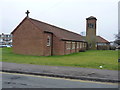
St Barnabas church, Kingshurst
The urban parish church of Kingshurst, whose foundation stone was dedicated in Sept 1955 by Mrs Leonard Wilson, wife of the then Bishop of Birmingham.
Image: © Richard Law
Taken: 10 Feb 2015
0.14 miles
4
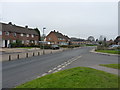
Silver Birch Road, Kingshurst
Many of the roads on this part of the Kingshurst housing estate have an arboreal bent to them - Ash, Acacia, Laburnum, Maple and Elm also feature nearby.
Image: © Richard Law
Taken: 10 Feb 2015
0.17 miles
5
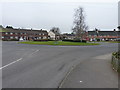
Estate roundabout in Kingshurst
At the junction of Acacia Avenue and Silver Birch Road.
Image: © Richard Law
Taken: 10 Feb 2015
0.19 miles
6
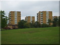
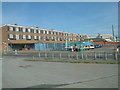
Highrise Flats
These flats are on Kingshurst Way photographed from near the River Cole.
Image: © Carl Baker
Taken: 20 Sep 2006
0.23 miles
7
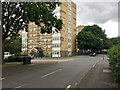
De Montfort House, Shirrall Grove, Kingshurst, east Birmingham
The map says 'Motte and Bailey Castle' in the area but I don't think this is it.
Image: © Robin Stott
Taken: 15 Jun 2018
0.25 miles