IMAGES TAKEN NEAR TO
Haywood Road, BIRMINGHAM, B33 0XP
Introduction
This page details the photographs taken nearby to Haywood Road, B33 0XP by members of the Geograph project.
The Geograph project started in 2005 with the aim of publishing, organising and preserving representative images for every square kilometre of Great Britain, Ireland and the Isle of Man.

There are currently over 7.5m images from over14,400 individuals and you can help contribute to the project by visiting https://www.geograph.org.uk
Image Map
Images are licensed for reuse under creativecommons.org/licenses/by-sa/2.0
Notes
- Clicking on the map will re-center to the selected point.
- The higher the marker number, the further away the image location is from the centre of the postcode.
Image Listing (20 Images Found)
Images are licensed for reuse under creativecommons.org/licenses/by-sa/2.0
Image
Details
Distance
1

Marston Green, Birmingham
Taken on final to Birmingham Airport.
Image: © Richard Cooke
Taken: 30 Sep 2014
0.15 miles
2
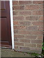
OS benchmark - Marston Green, no 66 Tile Cross Road
An OS cutmark on the front of no 66 Tile Cross Road; originally levelled in 1965 at 96.348m above Ordnance Datum Newlyn.
Image: © Richard Law
Taken: 6 May 2014
0.16 miles
3
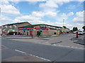
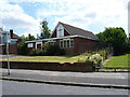
Convenience store in Kitts Green
At the junction of Shirestone Road with St Giles Road
Image: © Richard Law
Taken: 29 Jul 2014
0.17 miles
5
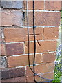
OS benchmark - Marston Green, no 111 Tile Cross Road
An OS cutmark at the side of no 111 Tile Cross Road; originally levelled in 1965 at 95.205m above Ordnance Datum Newlyn.
Image: © Richard Law
Taken: 6 May 2014
0.18 miles
6
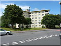
Leominster House, Tile Cross
One of a pair - there's a more or less identical block of flats a little further north along Tile Cross Road.
Image: © Richard Law
Taken: 30 May 2019
0.18 miles
7
Emmanuel Christian Fellowship church in Tile Cross
Situated on Shirestone Road in Tile Cross.
Image: © Richard Law
Taken: 29 Jul 2014
0.18 miles
8
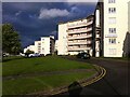
Tower Blocks, Shirestone Road
These six Y-shaped housing blocks were built in 1951, a time of acute housing shortage, for Birmingham County Borough Council (according to Lynsey Hanley in 'Estates', they were the first high-rise council housing in Birmingham). Each block is of 6 storeys with 30 dwellings, so, 180 homes in total. They were built by Wimpey to their 'no-fines' method (concrete made from clinker with no fine aggregates). They were named after Midlands country towns: Banbury, Ledbury, Leominster, Monmouth (now in Wales), Redditch and Stafford. Ledbury House can be seen in the foreground. See https://www.towerblock.eca.ed.ac.uk/development/tile-cross
Image: © A J Paxton
Taken: 8 May 2014
0.18 miles
9
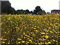
Wildflower meadow by Tile Cross Road
Looking towards the bus terminus, where a bus can be seen, and the buildings at the junction of Tile Cross Road with St. Giles Road and Bell Lane. The wildflowers have been planted at the edge of a small park between St. Giles Road and Mackadown Lane. The flowers appear to be mainly corn marigolds (yellow) with some corn chamomile (white petals) and cornflower (blue); there were also some poppies also (not visible in the photo) - a typical 'cornfield wildflower' seed packet mixture.
Image: © A J Paxton
Taken: 27 Aug 2014
0.20 miles
10
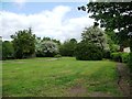
Open space, east of Mackadown Lane
Birmingham's eastern suburbs are blessed with many open spaces and parks.
Image: © Christine Johnstone
Taken: 16 May 2012
0.20 miles