IMAGES TAKEN NEAR TO
Seymour Close, BIRMINGHAM, B29 7JD
Introduction
This page details the photographs taken nearby to Seymour Close, B29 7JD by members of the Geograph project.
The Geograph project started in 2005 with the aim of publishing, organising and preserving representative images for every square kilometre of Great Britain, Ireland and the Isle of Man.

There are currently over 7.5m images from over14,400 individuals and you can help contribute to the project by visiting https://www.geograph.org.uk
Image Map
Images are licensed for reuse under creativecommons.org/licenses/by-sa/2.0
Notes
- Clicking on the map will re-center to the selected point.
- The higher the marker number, the further away the image location is from the centre of the postcode.
Image Listing (42 Images Found)
Images are licensed for reuse under creativecommons.org/licenses/by-sa/2.0
Image
Details
Distance
1
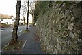
Wall alongside Upland Road, Selly Park
A large Victorian property lies on the other side of the wall. The wall itself is of fairly rough construction, apparently including large pieces of slag from metal smelting. I assume this was plentiful and cheap in the Midlands at the time the wall was built, and a good way of getting rid of waste materials.
Image: © Phil Champion
Taken: 14 Jan 2007
0.04 miles
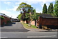
4
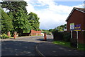
Selly Wick Drive
A private road into a private estate.
Image: © N Chadwick
Taken: 11 Jun 2011
0.08 miles
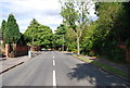
8
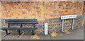
Corner of Selly Park Road and Selly Wick Road
Between the bench and lighting control box is an Ordnance Survey cut bench mark. It is shown on the 1917 1/2500 map with a height of 461.9 feet.
Image: © Paul Collins
Taken: 17 Jul 2018
0.10 miles
9
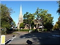
Church of St Stephen, Selly Hill
St Stephen's in Selly Hill was built in the early 1870s to a design by the architects Martin and Chamberlain, and attracted a Grade II listing https://britishlistedbuildings.co.uk/101343140-church-of-st-stephen-selly-oak-ward#.XhDbIkf7Tcs & https://historicengland.org.uk/listing/the-list/list-entry/1343140 in 1982.
Image: © Richard Law
Taken: 17 Oct 2019
0.10 miles