IMAGES TAKEN NEAR TO
Eachelhurst Road, BIRMINGHAM, B24 0NY
Introduction
This page details the photographs taken nearby to Eachelhurst Road, B24 0NY by members of the Geograph project.
The Geograph project started in 2005 with the aim of publishing, organising and preserving representative images for every square kilometre of Great Britain, Ireland and the Isle of Man.

There are currently over 7.5m images from over14,400 individuals and you can help contribute to the project by visiting https://www.geograph.org.uk
Image Map
Images are licensed for reuse under creativecommons.org/licenses/by-sa/2.0
Notes
- Clicking on the map will re-center to the selected point.
- The higher the marker number, the further away the image location is from the centre of the postcode.
Image Listing (37 Images Found)
Images are licensed for reuse under creativecommons.org/licenses/by-sa/2.0
Image
Details
Distance
1
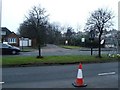
Plants Brook Nature Reserve entrance
View on Eachelhurst Road of entrance to nature reserve - opposite is river walk towards Penns Lane and walks in Pype Hayes Park.
Image: © Michael Westley
Taken: 6 Feb 2010
0.01 miles
2
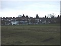
Pype Hayes Park, Eachelhurst Road
View from Plants Brook across the park to car showrooms on Eachelhurst Road, near to junction with Hansons Bridge Road.
Image: © Michael Westley
Taken: 6 Mar 2010
0.03 miles

4
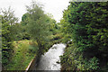
Plants Brook
A tributary of the River Tame about to disappear under Eachelhurst Road.
Image: © Bill Boaden
Taken: 4 Oct 2019
0.06 miles
5

OS benchmark - Pype Hayes, bridge parapet over the Plants Brook
An OS cutmark on the brickwork of the bridge over the stream, last levelled in 1965 at 90.39m above Ordnance Datum Newlyn.
Image: © Richard Law
Taken: 11 Mar 2020
0.07 miles
6

Eachelhurst Road
View of road, in direction of Plants Brook as it crosses under in direction of the nature reserve. Notice the brick wall to the right of the bus - this is the direction the brook takes and runs where the trees are to the right. There is a distinct break between housing where the brook runs.
Image: © Michael Westley
Taken: 6 Mar 2010
0.07 miles
7
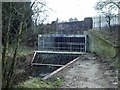
The Plants Brook in Pype Hayes
The steel and concrete construction in the foreground is a 'sump' for the brook, which has been engineered to flow underground all the rest of the way to its confluence with the Tame. It previously ran just north of the cluster of reservoirs east of here Image, then turned south through farmland west of Minworth, to join the Tame near Castle Bromwich; however it was being messed about with even by the late 19th century, as the 1889 maps suggests it had been diverted to allow the construction of the railways. The Castle Vale housing estate now occupies much of the land through which it formerly flowed, and the brook barely surfaces any more.
Image: © Richard Law
Taken: 11 Mar 2020
0.07 miles
8
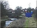
Plants Brook, Eachelhurst Road
View of Plants Brook as it reaches Eachelhurst Road Image Blue portacabin is likely in use by contractors working on road improvements nearby.
Image: © Michael Westley
Taken: 6 Mar 2010
0.07 miles
9
Road bridge / river culvert, Eachelhurst Road
Plants brook reaches Eachelhurst Road along boundary of Pype Hayes Park.
These extensive gates and railings prevent blockages /floods and unwanted access beneath the road. The river then continues into the nature reserve on the opposite side of the road.
Image: © Michael Westley
Taken: 6 Feb 2010
0.08 miles
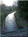
10
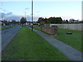
Looking north along Eachelhurst Road
The brick parapet in the foreground marks the former position of the road bridge over the Plants Brook, which is now culverted for the rest of its course to the River Tame.
Image: © Richard Law
Taken: 11 Mar 2020
0.09 miles