IMAGES TAKEN NEAR TO
Granville Street, BIRMINGHAM, B1 1JW
Introduction
This page details the photographs taken nearby to Granville Street, B1 1JW by members of the Geograph project.
The Geograph project started in 2005 with the aim of publishing, organising and preserving representative images for every square kilometre of Great Britain, Ireland and the Isle of Man.

There are currently over 7.5m images from over14,400 individuals and you can help contribute to the project by visiting https://www.geograph.org.uk
Image Map
Images are licensed for reuse under creativecommons.org/licenses/by-sa/2.0
Notes
- Clicking on the map will re-center to the selected point.
- The higher the marker number, the further away the image location is from the centre of the postcode.
Image Listing (330 Images Found)
Images are licensed for reuse under creativecommons.org/licenses/by-sa/2.0
Image
Details
Distance
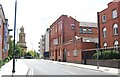
1
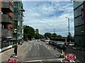
Bath Row
Looking towards Holloway Road.
Image: © Andrew Abbott
Taken: 14 Jul 2024
0.03 miles
2
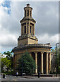
Former church, Bath Row, Birmingham
Rickman & Hutchinson's elegant Greek Revival church of 1826-29 (St Thomas) was mostly destroyed by a bomb in 1941. Grade II listed.
Image: © Stephen Richards
Taken: 22 Jun 2015
0.05 miles
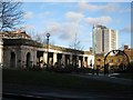
3
St Thomas' Peace Garden in Birmingham
On the right is the remaining tower of St. Thomas' Church. On the night of 11 December 1940, all but the tower and west portico of the church was destroyed in the Birmingham Blitz.
Image: © Mat Fascione
Taken: 27 Sep 2015
0.05 miles
4
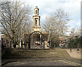
St. Thomas's Church seen from The Peace Gardens, Birmingham
Image: © habiloid
Taken: 2 Mar 2013
0.05 miles
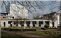
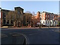
6
Peace Garden, St Thomas's, Bath Row
On site of former St Thomas's church there now stands a peace garden. Bordered by Granville Street, Bath Row, Ridley Street and Washington Street.
Robert de Lloyd published the following in 2000:
St Thomas's church was one of the two Greek revival churches in Birmingham designed by Rickman and Hutchinson. The Church, which had been refitted in 1893, was largely destroyed by enemy action in 1940, but the tower and the west porticos are still (1961) standing. http://archiver.rootsweb.ancestry.com/th/read/WARWICK/2000-03/0952294736
Image: © Michael Westley
Taken: 26 Dec 2009
0.06 miles
9
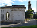
Former hospital, Bath Row, Birmingham
One of two surviving blocks of what was Queen's Hospital, by Bateman & Drury, 1840-41. The other is seen here Image Grade II listed.
Now flats.
Image: © Stephen Richards
Taken: 22 Jun 2015
0.08 miles
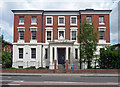
10
Former Queen's Hospital, Bath Row
The Queen's Hospital opened in 1841 as one of the first British institutions opened specifically as a teaching hospital. Its early years were blighted by the narrowness of its Church of England principles, but it flourished after it was refounded in 1867; see the site of the Birmingham University Medical School, which traces its origins to this institution https://www.birmingham.ac.uk/schools/medical-school/about/history.aspx .
The east block was built around 1841 to designs by Bateman and Devey in the Regency style. The west block, a building in an Italianate style by J H Chamberlain, was added in 1873. Both are now listed buildings; descriptions can be found on the Historic England site https://historicengland.org.uk/listing/the-list/list-entry/1219917?section=official-list-entry https://historicengland.org.uk/listing/the-list/list-entry/1075749?section=official-list-entry .
From 1941 to 1993 the buildings were used as an accident hospital. They have since been converted into flats.
Image: © A J Paxton
Taken: 20 Mar 2022
0.09 miles