IMAGES TAKEN NEAR TO
Washington Street, BIRMINGHAM, B1 1JR
Introduction
This page details the photographs taken nearby to Washington Street, B1 1JR by members of the Geograph project.
The Geograph project started in 2005 with the aim of publishing, organising and preserving representative images for every square kilometre of Great Britain, Ireland and the Isle of Man.

There are currently over 7.5m images from over14,400 individuals and you can help contribute to the project by visiting https://www.geograph.org.uk
Image Map
Images are licensed for reuse under creativecommons.org/licenses/by-sa/2.0
Notes
- Clicking on the map will re-center to the selected point.
- The higher the marker number, the further away the image location is from the centre of the postcode.
Image Listing (347 Images Found)
Images are licensed for reuse under creativecommons.org/licenses/by-sa/2.0
Image
Details
Distance
2
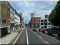
Holloway Road
Towards Birmingham City Centre.
Image: © Andrew Abbott
Taken: 14 Jul 2024
0.04 miles
3
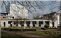
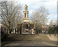
Peace Garden, St Thomas's, Bath Row
On site of former St Thomas's church there now stands a peace garden. Bordered by Granville Street, Bath Row, Ridley Street and Washington Street.
Robert de Lloyd published the following in 2000:
St Thomas's church was one of the two Greek revival churches in Birmingham designed by Rickman and Hutchinson. The Church, which had been refitted in 1893, was largely destroyed by enemy action in 1940, but the tower and the west porticos are still (1961) standing. http://archiver.rootsweb.ancestry.com/th/read/WARWICK/2000-03/0952294736
Image: © Michael Westley
Taken: 26 Dec 2009
0.05 miles
5
St. Thomas's Church seen from The Peace Gardens, Birmingham
Image: © habiloid
Taken: 2 Mar 2013
0.06 miles
6
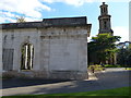
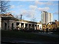
St Thomas' Peace Garden in Birmingham
On the right is the remaining tower of St. Thomas' Church. On the night of 11 December 1940, all but the tower and west portico of the church was destroyed in the Birmingham Blitz.
Image: © Mat Fascione
Taken: 27 Sep 2015
0.06 miles
7
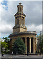
Former church, Bath Row, Birmingham
Rickman & Hutchinson's elegant Greek Revival church of 1826-29 (St Thomas) was mostly destroyed by a bomb in 1941. Grade II listed.
Image: © Stephen Richards
Taken: 22 Jun 2015
0.06 miles
8
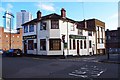
The Gough Arms (1), 52 Upper Gough Street, Birmingham
Located on the corner of Upper Gough Street and Marshall Street. Some time after this photograph was taken this public house closed. It re-opened in the summer of 2014 under the new name of the Keg & Grill. As the name implies, food is available.
Image
Image: © P L Chadwick
Taken: 25 Nov 2012
0.06 miles
9
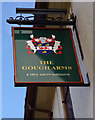
The Gough Arms (2) - sign, 52 Upper Gough Street, Birmingham
The Gough family were presumably local landowners as there are at least two streets named after them, as well as this pub. The pub is now known as the Keg & Grill and therefore this sign has been replaced.
Image
Image: © P L Chadwick
Taken: 25 Nov 2012
0.06 miles
10

Birmingham Chinese Evangelical Church (BCEC), 14 Upper Gough Street, Birmingham
The church's website says:- "The BCEC is an Evangelical Church that believes in the authority of scripture and the divine nature of the triune God. Our beliefs are summarised best in the Apostle’s Creed". The location is not far from the city's Chinese Quarter. Every week separate services are held in English, Cantonese and Mandarin. The church also attracts non-Chinese worshippers.
The church was founded about ten years ago and is one of only three Chinese churches in the city. The red shutters over the door and windows can be fully closed when the building is not in use.
Image: © P L Chadwick
Taken: 25 Nov 2012
0.07 miles