IMAGES TAKEN NEAR TO
Bluebridge Road, HATFIELD, AL9 7SA
Introduction
This page details the photographs taken nearby to Bluebridge Road, AL9 7SA by members of the Geograph project.
The Geograph project started in 2005 with the aim of publishing, organising and preserving representative images for every square kilometre of Great Britain, Ireland and the Isle of Man.

There are currently over 7.5m images from over14,400 individuals and you can help contribute to the project by visiting https://www.geograph.org.uk
Image Map
Images are licensed for reuse under creativecommons.org/licenses/by-sa/2.0
Notes
- Clicking on the map will re-center to the selected point.
- The higher the marker number, the further away the image location is from the centre of the postcode.
Image Listing (7 Images Found)
Images are licensed for reuse under creativecommons.org/licenses/by-sa/2.0
Image
Details
Distance
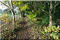
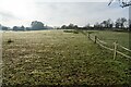
1
Blue Bridge Road, Brookmans Park
Descending southwards towards the Blue Bridge.
Image: © Christine Johnstone
Taken: 10 Apr 2015
0.01 miles
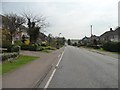
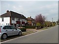
2
Houses on the east side of Blue Bridge Road
At the south-western corner of Brookmans Park.
Image: © Christine Johnstone
Taken: 10 Apr 2015
0.04 miles
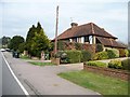
3
Houses on the west side of Blue Bridge Road
In the south-west corner of Brookmans Park.
Image: © Christine Johnstone
Taken: 10 Apr 2015
0.05 miles
5
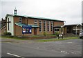
Brookmans Park United Reformed Church
The church is on Blue Bridge Road at its junction with Oaklands Avenue.
Image: © Nigel Cox
Taken: 24 Sep 2008
0.20 miles
6
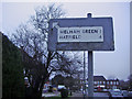
Pre-Worboys sign Brookmans Park
On Bluebridge Road in the village centre, opposite the hotel.
Image: © David Howard
Taken: 31 Dec 2008
0.20 miles