IMAGES TAKEN NEAR TO
High Road, HATFIELD, AL9 6HW
Introduction
This page details the photographs taken nearby to High Road, AL9 6HW by members of the Geograph project.
The Geograph project started in 2005 with the aim of publishing, organising and preserving representative images for every square kilometre of Great Britain, Ireland and the Isle of Man.

There are currently over 7.5m images from over14,400 individuals and you can help contribute to the project by visiting https://www.geograph.org.uk
Image Map
Images are licensed for reuse under creativecommons.org/licenses/by-sa/2.0
Notes
- Clicking on the map will re-center to the selected point.
- The higher the marker number, the further away the image location is from the centre of the postcode.
Image Listing (45 Images Found)
Images are licensed for reuse under creativecommons.org/licenses/by-sa/2.0
Image
Details
Distance
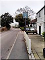
4

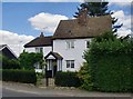
Essendon: The Rose and Crown public house
A public house with a weatherboarded first floor located on the east side of the B158 High Road.
Image: © Nigel Cox
Taken: 3 Mar 2008
0.04 miles
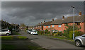
6

Preserved Green Bus in Essendon
Taken on the B158 High Road, this photo shows a preserved London Transport country bus RF539 (NLE 539) on a short tour from Potters Bar Bus Garage, which was having an Open Day. The vehicle is an AEC Regal IV with Metro-Cammell 39-seater bodywork dating from the early 1950s. Essendon used to be served by routes 350/350A which were operated by London Transport green buses from Hertford bus garage in the 1960s, then by London Country Bus Services in the 1970s. The village is now served by route 341 operated by UNO on weekdays. The Rose & Crown pub can be seen behind the bus.
Image: © David Hillas
Taken: 11 Jul 2015
0.04 miles
7
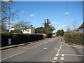
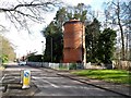
Essendon: B158 High Road
Viewed from the junction with School Lane, the War Memorial stands out against the dark green vegetation. The church spire is just visible over the trees to the right of the large white house.
Image: © Nigel Cox
Taken: 3 Mar 2008
0.11 miles
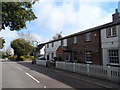
8
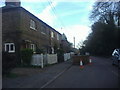
Weather-boarded cottages in the High Road, Essendon
Image: © Stefan Czapski
Taken: 11 Aug 2013
0.11 miles