IMAGES TAKEN NEAR TO
Normans Lane, WELWYN, AL6 9TQ
Introduction
This page details the photographs taken nearby to Normans Lane, AL6 9TQ by members of the Geograph project.
The Geograph project started in 2005 with the aim of publishing, organising and preserving representative images for every square kilometre of Great Britain, Ireland and the Isle of Man.

There are currently over 7.5m images from over14,400 individuals and you can help contribute to the project by visiting https://www.geograph.org.uk
Image Map
Images are licensed for reuse under creativecommons.org/licenses/by-sa/2.0
Notes
- Clicking on the map will re-center to the selected point.
- The higher the marker number, the further away the image location is from the centre of the postcode.
Image Listing (12 Images Found)
Images are licensed for reuse under creativecommons.org/licenses/by-sa/2.0
Image
Details
Distance
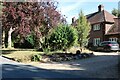
1
Spinney Lane, Rabley Heath
At the end of Slip Lane.
Image: © David Howard
Taken: 7 Aug 2022
0.16 miles
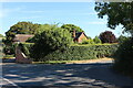
2
Rableyheath: Pottersheath Road/Rableyheath Road/Spinney Lane junction
These lanes are in order left to right across the photograph respectively. There is an isolated rural letter box in view and Rableyheath Water Tower in Image beyond.
Image: © Nigel Cox
Taken: 22 Nov 2015
0.18 miles
6
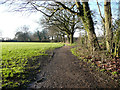
Public footpath off Spinney Lane, Knebworth
The path goes along the left side of the row of trees.
Image: © Humphrey Bolton
Taken: 15 Jan 2020
0.23 miles
7
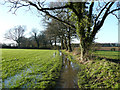
Flooded footpath off Spinney Lane, Knebworth
Like a narrow canal, and the field at the side looks rather wet.
Image: © Humphrey Bolton
Taken: 15 Jan 2020
0.24 miles
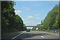
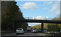
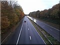
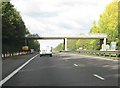
10
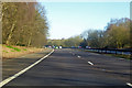
A1(M) northbound
Between junctions 6 and 7.
Image: © Robin Webster
Taken: 17 Feb 2018
0.25 miles