IMAGES TAKEN NEAR TO
Codicote Road, WELWYN, AL6 9NG
Introduction
This page details the photographs taken nearby to Codicote Road, AL6 9NG by members of the Geograph project.
The Geograph project started in 2005 with the aim of publishing, organising and preserving representative images for every square kilometre of Great Britain, Ireland and the Isle of Man.

There are currently over 7.5m images from over14,400 individuals and you can help contribute to the project by visiting https://www.geograph.org.uk
Image Map
Images are licensed for reuse under creativecommons.org/licenses/by-sa/2.0
Notes
- Clicking on the map will re-center to the selected point.
- The higher the marker number, the further away the image location is from the centre of the postcode.
Image Listing (58 Images Found)
Images are licensed for reuse under creativecommons.org/licenses/by-sa/2.0
Image
Details
Distance
2

View of a pony in the Cat Survival Trust
Looking south-southeast.
Image: © Robert Lamb
Taken: 10 Jun 2017
0.07 miles
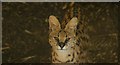
3
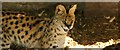
View of a serval in the Cat Survival Trust #4
Looking south-southeast.
Image: © Robert Lamb
Taken: 10 Jun 2017
0.07 miles
4
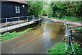
Welwyn Ford
Ford beside the mill at Welwyn.
Image: © John Walton
Taken: 12 May 2013
0.07 miles
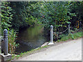
5
River Mimram: Fulling Mill Lane Ford
Although the river mainly flows through the old mill, and under the road, the water in this mill bypass channel crosses the road in a culvert that can become full in periods of heavy flow, creating a ford. Please see Image] for a picture of the site with the ford in operation.
Image: © Nigel Cox
Taken: 22 Nov 2015
0.07 miles
6
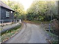
River Mimram, Oakhills Wood
Here the River Mimram passes under Fulling Mill Lane just outside Welwyn; this is a ford when river levels are high. There was a water mill here (the building still survives) fed by a separate channel. The Mimram flows for 12 miles across Hertfordshire rising near Whitwell and is a tributary of the River Lea.
Image: © Stephen McKay
Taken: 12 Oct 2021
0.08 miles
7

View of a lemur in the Cat Survival Trust
Looking south-southeast.
Image: © Robert Lamb
Taken: 10 Jun 2017
0.08 miles
8
View of a serval in the Cat Survival Trust #5
Looking south-southeast.
Image: © Robert Lamb
Taken: 10 Jun 2017
0.08 miles
9

View of a lemur in the Cat Survival Trust #2
Looking south-southeast.
Image: © Robert Lamb
Taken: 10 Jun 2017
0.08 miles
10
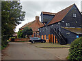
Fulling Mill near Welwyn
Actually within the parish of Codicote but closer to Welwyn, this early 19th century watermill is grade II listed. It was fed by the River Mimram. It is now used as offices.
Image: © Stephen McKay
Taken: 12 Oct 2021
0.09 miles