IMAGES TAKEN NEAR TO
St. Martins Close, HARPENDEN, AL5 5JG
Introduction
This page details the photographs taken nearby to St. Martins Close, AL5 5JG by members of the Geograph project.
The Geograph project started in 2005 with the aim of publishing, organising and preserving representative images for every square kilometre of Great Britain, Ireland and the Isle of Man.

There are currently over 7.5m images from over14,400 individuals and you can help contribute to the project by visiting https://www.geograph.org.uk
Image Map (Loading...)


Getting Data...Please wait
Leaflet Map data © OpenStreetMap
Images are licensed for reuse under creativecommons.org/licenses/by-sa/2.0
Notes
- Clicking on the map will re-center to the selected point.
- The higher the marker number, the further away the image location is from the centre of the postcode.
Image Listing (48 Images Found)
Images are licensed for reuse under creativecommons.org/licenses/by-sa/2.0
Image
Details
Distance
1
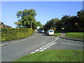
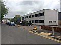
Northfield Road Batford
Looking up the road from the junction with Porters Hill
Image: © Gary Fellows
Taken: 26 Sep 2008
0.05 miles
3

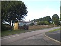
Coldharbour Lane Allotments
Entrance to Coldharbour Lane Allotments in Batford
Image: © Gary Fellows
Taken: 11 Oct 2007
0.12 miles
4
Porters Hill at the junction of Lower Luton Road
Image: © David Howard
Taken: 27 Aug 2015
0.12 miles
5

Bungalows on Lower Luton Road, Batford
Image: © David Howard
Taken: 27 Aug 2015
0.15 miles
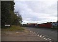
6
Lower Luton Road (B653)
Heading south east.
Image: © JThomas
Taken: 22 Feb 2014
0.16 miles
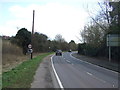
8
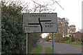
Road sign, Batford
What is at first sight an ordinary road sign, on the approach to the staggered junction at the west end of Batford. The problem is that the road to the left, whilst it does go to Harpenden, is not the B651, nor does it lead to, or go anywhere near, the B651, which is a north-south road some three miles to the east. It is not even a "B" road, being unclassified.
Image: © Ian Capper
Taken: 24 Mar 2011
0.17 miles

10
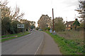
Lower Luton Road
On its approach to the junction with Bower Heath Lane and Westfield Road. For close up of the sign on the left, see Image
Image: © Ian Capper
Taken: 24 Mar 2011
0.18 miles