IMAGES TAKEN NEAR TO
The Uplands, HARPENDEN, AL5 2PA
Introduction
This page details the photographs taken nearby to The Uplands, AL5 2PA by members of the Geograph project.
The Geograph project started in 2005 with the aim of publishing, organising and preserving representative images for every square kilometre of Great Britain, Ireland and the Isle of Man.

There are currently over 7.5m images from over14,400 individuals and you can help contribute to the project by visiting https://www.geograph.org.uk
Image Map
Images are licensed for reuse under creativecommons.org/licenses/by-sa/2.0
Notes
- Clicking on the map will re-center to the selected point.
- The higher the marker number, the further away the image location is from the centre of the postcode.
Image Listing (8 Images Found)
Images are licensed for reuse under creativecommons.org/licenses/by-sa/2.0
Image
Details
Distance
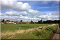
3
Houses beyond the fields
Looking NE from the footpath junction at TL128115, over the fields we can see the houses which just creep into the NE corner of the square.
Image: © Rob Hinkley
Taken: 29 May 2006
0.15 miles
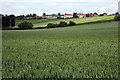
4
Beesonend Lane looking towards Beesonend Farm
Image: © Robert Eva
Taken: 7 Mar 2017
0.17 miles
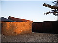
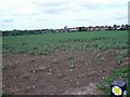
7
Beesonend Farm building
A pumping station ? Any identification of what this is would be gladly received.
Image: © Robert Eva
Taken: 7 Mar 2017
0.22 miles
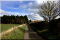
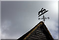
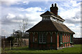
8
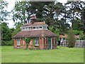
Strange little building
This unusual little building stands in the grounds of Beesonend Farm House. I've classified it as a shed, but I'm sure there is - or at least was - more to it than that.
Image: © Rob Hinkley
Taken: 29 May 2006
0.24 miles