IMAGES TAKEN NEAR TO
Woodcock Hill, ST. ALBANS, AL4 9HQ
Introduction
This page details the photographs taken nearby to Woodcock Hill, AL4 9HQ by members of the Geograph project.
The Geograph project started in 2005 with the aim of publishing, organising and preserving representative images for every square kilometre of Great Britain, Ireland and the Isle of Man.

There are currently over 7.5m images from over14,400 individuals and you can help contribute to the project by visiting https://www.geograph.org.uk
Image Map
Images are licensed for reuse under creativecommons.org/licenses/by-sa/2.0
Notes
- Clicking on the map will re-center to the selected point.
- The higher the marker number, the further away the image location is from the centre of the postcode.
Image Listing (15 Images Found)
Images are licensed for reuse under creativecommons.org/licenses/by-sa/2.0
Image
Details
Distance
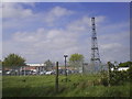
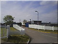
2
Radio antenna at HOSDB Research Centre Sandridge
There are two of these centres, one here and the other in Langhurst, Sussex. They are for government scientific research. https://www.gov.uk/government/collections/centre-for-applied-science-and-technology-information
Image: © David Howard
Taken: 5 Jan 2017
0.04 miles
3
HOSDB (Home Office Scientific Development Branch) Sandridge
The original site began 1939 as a wireless intercept station for the Foreign Office operated by GPO radio engineers and was used to intercept diplomatic traffic between enemy governments and their embassies. Initially the messages were in morse code but later Germany used high speed encryption and transmission equipment that needed to be recorded by undulators, a mechanised paper strip inking system. The results were sent by teleprinter to Bletchley park for decryption. The messages were of the highest value to Winston Churchill who received assessments every day. After WW2 it became part of the Diplomatic Wireless Service and remained largely unchanged until 1973 when it was handed over to the Home office. Sources - National Archives file HW55/3 & HW14/102, http://www.ystations.webs.com/
Image: © Chris Reynolds
Taken: 23 Apr 2009
0.04 miles
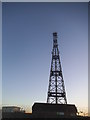
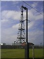
4
Wireless Mast, Woodcock Hill, Sandridge
Intriguing – This old-fashioned looking radio mast is stuck on the top of a minor hill in the Hertfordshire countryside and looks most incongruous. The map marks it as a wireless station and there are some mysterious road signs to “HOSDB”. I must find our more ... Image
Image: © Chris Reynolds
Taken: 23 Apr 2009
0.04 miles
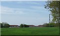
6
Radio Mast
Situated at the HOSDB research centre
Image: © Gary Fellows
Taken: 12 May 2009
0.05 miles
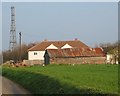
7
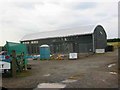
New Dutch Barn workshops Fairfolds Farm
This is obviously a farm refurbished as business premises
Image: © Jack Hill
Taken: 19 Aug 2005
0.07 miles
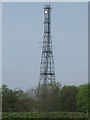
8
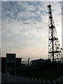
Signal mast and razor wire
Looking almost straight into the sun from TL185104 at the signal mast on the road coming east out of Sandridge.
No normal phone mast this; the thing's ringed with two layers of razor wire fence and has a sign at the entrance with a royal coat of arms on it. Photo notes: for better results take photo in morning, not afternoon like I did - the mast's partially obscured by trees from the west, so better to be east of it with the sun behind you.
Image: © Rob Hinkley
Taken: 28 Mar 2005
0.12 miles
10
Signal mast
Looking E to the signal mast at TL184103.
Image: © Rob Hinkley
Taken: 28 Mar 2005
0.16 miles