IMAGES TAKEN NEAR TO
Marshalls Heath Lane, ST. ALBANS, AL4 8HS
Introduction
This page details the photographs taken nearby to Marshalls Heath Lane, AL4 8HS by members of the Geograph project.
The Geograph project started in 2005 with the aim of publishing, organising and preserving representative images for every square kilometre of Great Britain, Ireland and the Isle of Man.

There are currently over 7.5m images from over14,400 individuals and you can help contribute to the project by visiting https://www.geograph.org.uk
Image Map
Images are licensed for reuse under creativecommons.org/licenses/by-sa/2.0
Notes
- Clicking on the map will re-center to the selected point.
- The higher the marker number, the further away the image location is from the centre of the postcode.
Image Listing (7 Images Found)
Images are licensed for reuse under creativecommons.org/licenses/by-sa/2.0
Image
Details
Distance
3
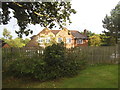
The first house in Marshalls Heath
It's the first coming from the south anyway
Image: © David Howard
Taken: 27 Aug 2015
0.05 miles
4
Marshalls Heath
What you see is virtually the entire village
Image: © David Howard
Taken: 27 Aug 2015
0.05 miles
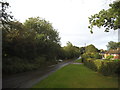
5
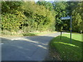
Marshalls Heath Lane
Taken at the turning which eventually takes you into Mackerye End
Image: © Gary Fellows
Taken: 10 Oct 2008
0.06 miles
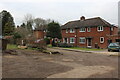
6
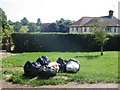
Collection day at Marshalls Heath
This is the last house in the row, I hope that all that rubbish isn't from them
Image: © Jack Hill
Taken: 31 Aug 2005
0.10 miles
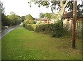
7
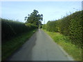
Country Lane
Heading towards Mackerye End
Image: © Gary Fellows
Taken: 10 Oct 2008
0.12 miles