IMAGES TAKEN NEAR TO
North Orbital Road, ST. ALBANS, AL4 0RY
Introduction
This page details the photographs taken nearby to North Orbital Road, AL4 0RY by members of the Geograph project.
The Geograph project started in 2005 with the aim of publishing, organising and preserving representative images for every square kilometre of Great Britain, Ireland and the Isle of Man.

There are currently over 7.5m images from over14,400 individuals and you can help contribute to the project by visiting https://www.geograph.org.uk
Image Map
Images are licensed for reuse under creativecommons.org/licenses/by-sa/2.0
Notes
- Clicking on the map will re-center to the selected point.
- The higher the marker number, the further away the image location is from the centre of the postcode.
Image Listing (11 Images Found)
Images are licensed for reuse under creativecommons.org/licenses/by-sa/2.0
Image
Details
Distance

2
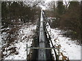
Tyttenhanger: Gravel pit conveyor belt
This is the view in the opposite direction to Image as the conveyor belt rises to cross over the River Colne to reach the batching plant.
Image: © Nigel Cox
Taken: 14 Jan 2010
0.15 miles
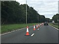
3
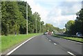
A414 (North Orbital Road) near Colney Heath
Image: © Mr Ignavy
Taken: 24 Oct 2010
0.16 miles
4
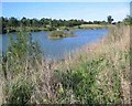
Bowmans Lakes
This is one of several lakes used for wash water by Lafarge Sand and Gravel. It is a haven for water birds and fishermen
Image: © Jack Hill
Taken: 10 Jun 2005
0.17 miles
6
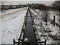
Tyttenhanger: Gravel pit conveyor belt
Reviewing old Ordnance Survey maps of this area the abstraction of gravel appears to be a comparatively recent development, with a 1960s 1:10,000 scale map showing the original hedge and field layout alongside the River Colne largely intact since historic times. By 1971 though the first gravel pits had appeared on the mapping, and the area is currently actively worked. On the day of the photograph the belt was running but not carrying gravel. This view was taken from the bridge carrying a public footpath over the conveyor belt. For a view in the opposite direction please see Image
Image: © Nigel Cox
Taken: 14 Jan 2010
0.19 miles
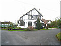
8
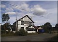
Evidence of a former pub
The Barley Mow sign.
Image: © Mr Ignavy
Taken: 27 Oct 2011
0.24 miles