IMAGES TAKEN NEAR TO
High Street, ST. ALBANS, AL4 0NP
Introduction
This page details the photographs taken nearby to High Street, AL4 0NP by members of the Geograph project.
The Geograph project started in 2005 with the aim of publishing, organising and preserving representative images for every square kilometre of Great Britain, Ireland and the Isle of Man.

There are currently over 7.5m images from over14,400 individuals and you can help contribute to the project by visiting https://www.geograph.org.uk
Image Map
Images are licensed for reuse under creativecommons.org/licenses/by-sa/2.0
Notes
- Clicking on the map will re-center to the selected point.
- The higher the marker number, the further away the image location is from the centre of the postcode.
Image Listing (18 Images Found)
Images are licensed for reuse under creativecommons.org/licenses/by-sa/2.0
Image
Details
Distance
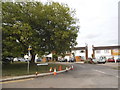
2
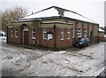
Colney Heath: The Crooked Billet
This Grade II Listed pub is on the High Street. The English Heritage Listed Buildings website describes the exterior thus:-
"Circa early C19 with later C19 extensions. Weatherboarded timber frame with plain tile roof, hipped on right. Rendered brick extension with slate roofs. Brick axial stacks. The original house was a 2-room plan weatherboarded cottage with a central axial stack. The right hand (S) bay was added later in C19 and the back range (E) is even later C19 or early C20. There are outshuts on the left (N) and rear (E) of the original cottage. 2 storeys. 3-window west front. C19 2-light casements with glazing bars. Panelled and glazed door to right of centre with small C20 gabled porch; another door on left with glazed door and canopy. Weatherboarded outshut on left and taller brick range at rear."
Image: © Nigel Cox
Taken: 14 Jan 2010
0.04 miles
3
The Crooked Billet Pub Beer Garden
A place where children play and adults drink seemingly in their separate spheres. A shot in black and white seemed to accentuate the separation of these two worlds.
Image: © John Kingdon
Taken: 10 Sep 2023
0.05 miles
4
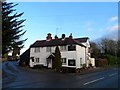
The Crooked Billet pub, Colney Heath
Early C19 See http://www.britishlistedbuildings.co.uk/en-436443-the-crooked-billet-public-house-colney-h for entry in British Listed Buildings
Image: © Bikeboy
Taken: 31 Dec 2014
0.05 miles
5
Colney Heath: The Village Hall
The Village Hall also serves as the office of the local Colney Heath Parish Council whose website is here http://colneyheath.org.uk/component/option,com_frontpage/Itemid,1/
The hall is available to hire and, according to the Herts Direct website http://www.hertsdirect.org/comdirectory/comvol/venue2y/vntown3y/10980172 offers seating for 150, or dancing for 120.
Image: © Nigel Cox
Taken: 14 Jan 2010
0.09 miles
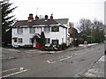
6
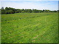
Colney Heath
Viewed looking from Colney Heath High Street the River Colne runs in the trees in the distance.
Image: © Nigel Cox
Taken: 4 Jun 2006
0.17 miles
9
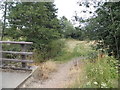
Field entrance on Church Road, Colney Heath
Image: © David Howard
Taken: 23 Jul 2015
0.19 miles
10
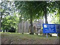
St Marks Church Colney Heath
Wonder if the congregation stays at home and logs on to the sermons
Image: © Jack Hill
Taken: 2 Aug 2005
0.20 miles