IMAGES TAKEN NEAR TO
High Street, ST. ALBANS, AL3 4EW
Introduction
This page details the photographs taken nearby to High Street, AL3 4EW by members of the Geograph project.
The Geograph project started in 2005 with the aim of publishing, organising and preserving representative images for every square kilometre of Great Britain, Ireland and the Isle of Man.

There are currently over 7.5m images from over14,400 individuals and you can help contribute to the project by visiting https://www.geograph.org.uk
Image Map
Images are licensed for reuse under creativecommons.org/licenses/by-sa/2.0
Notes
- Clicking on the map will re-center to the selected point.
- The higher the marker number, the further away the image location is from the centre of the postcode.
Image Listing (863 Images Found)
Images are licensed for reuse under creativecommons.org/licenses/by-sa/2.0
Image
Details
Distance
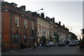
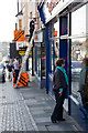
1
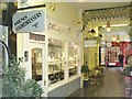
St Albans - Arcade
A change in tempo from the streets outside.
Image: © Colin Smith
Taken: 13 Aug 2016
0.01 miles
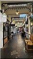
3
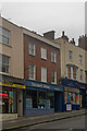
Shop and Restaurants, High Street
Alloro is situated behind the shop down a passageway. I thought that their food and service was very good when I visited.
Image: © Paul Collins
Taken: 27 Oct 2021
0.01 miles
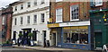
5
High Street
Perhaps the shortest High Street in the country, being less than 100m long. Historically, it formed part of the main route out of St Albans to the northwest, originally through its extension along George Street, and later along Verulam Road, following the building of this improved route by Thomas Telford in 1825.
The buildings on the left now are occupied by the Cote Brasserie. Prior to 2009 it was a pub, The Vintry, with the nearer part previously being a Barclays Bank. They are grade II listed - see www.historicengland.org.uk/listing/the-list/list-entry/1103128.
Image: © Ian Capper
Taken: 3 Dec 2011
0.02 miles
6
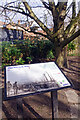
NEW
The Verdun Tree
The accompanying information board explains the significance of the horse chestnut tree behind. It was grown from a conker that had come from one of the few surviving trees on the First World War battlefield at Verdun. The tree was planted in 1976 to mark the 60th anniversary of the battle.
Image: © Stephen McKay
Taken: 11 Mar 2025
0.02 miles
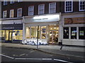
7
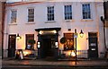
Cote Brasserie on London Road, St Albans
Image: © David Howard
Taken: 4 May 2019
0.02 miles
8
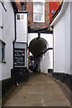
NEW
Waxhouse Gate, St Albans
It is known that there has been a gate here, connecting the cathedral and the town, since at least the 15th century although it was reconstructed in the 18th. The name derives from the production of candles in the alley for the use of pilgrims coming to the shrine of St Alban.
Image: © Stephen McKay
Taken: 11 Mar 2025
0.02 miles
9
Holywell Hill
Part of a line of buildings at the top end of Holywell Hill, 18th/19th century replacements of earlier buildings. In the centre is no 6, now housing an estate agency, flanked by nos 8 and 4. All three are locally listed.
Image: © Ian Capper
Taken: 4 Dec 2011
0.02 miles
10
Upcoming Election
Two days after the announcement of the date for the 2010 General Election, the candidates boards are being mounted on Holywell Hill, St. Albans.
Image: © Martin Addison
Taken: 8 Apr 2010
0.02 miles