IMAGES TAKEN NEAR TO
Nelson Avenue, ST. ALBANS, AL1 5SE
Introduction
This page details the photographs taken nearby to Nelson Avenue, AL1 5SE by members of the Geograph project.
The Geograph project started in 2005 with the aim of publishing, organising and preserving representative images for every square kilometre of Great Britain, Ireland and the Isle of Man.

There are currently over 7.5m images from over14,400 individuals and you can help contribute to the project by visiting https://www.geograph.org.uk
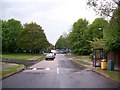
Image Map
Images are licensed for reuse under creativecommons.org/licenses/by-sa/2.0
Notes
- Clicking on the map will re-center to the selected point.
- The higher the marker number, the further away the image location is from the centre of the postcode.
Image Listing (23 Images Found)
Images are licensed for reuse under creativecommons.org/licenses/by-sa/2.0
Image
Details
Distance
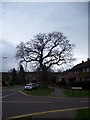
1
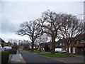
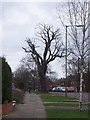
Old Oaks, Nelson Avenue
These trees are part of our community heritage and mark an old field/path boundary before the houses were built. They are two of many similar natural architectural monuments in this area of St Albans, Herts and require respect and preservation.
Image: © anthony helm
Taken: 2 Mar 2007
0.07 miles
2
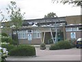
Francis Bacon School Drakes Drive
The pipework on the roof idicates that there may be some air conditioning for the offices.
Image: © Jack Hill
Taken: 12 Aug 2005
0.08 miles
3
Drakes Drive, Sopwell
Looking towards Admirals Walk
Image: © David Howard
Taken: 28 May 2015
0.10 miles
4
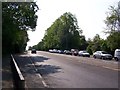
Line of trees on west side of London Road
These trees in the centre of the picture, have Tree Preservation Orders on them and are just south of Mile House Lane junction. The older detached houses are being redeveloped behind them.
Image: © anthony helm
Taken: 28 Apr 2007
0.11 miles
5
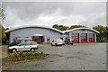
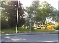
St Albans fire station
St Albans fire station, 153 London Road, St Albans, Hertfordshire, in its completed state. Compare this with Image This station has replaced the old one in Harpenden Road Image
Image: © Kevin Hale
Taken: 13 Nov 2006
0.12 miles
6
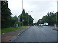
A1081 London Road, London Colney
At the junction with Drakes Drive
Image: © Geographer
Taken: 3 Jul 2012
0.12 miles
7
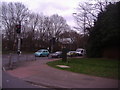
Corner of Mile House Road and London Road Sopwell
Image: © David Howard
Taken: 11 Mar 2011
0.15 miles
8
Urban Oak in Winter
This dormant Oak is in Cell Barnes Road, St Albans - looking north-west towards the shops. It is one of quite a few which marks an historic boundary or route. In this case Cell barnes Lane was before the Second World War very small and rural. After the War the current housing estate was built on farmland. The Oaks are the reminders of time past.
Image: © anthony helm
Taken: 2 Mar 2007
0.16 miles
9
Mile House Pub - development site
Over-night the Mile House Pub on London Road, St Albans, was pulled down by developers. Whilst not a listed, this building was a valued community resource in south St Albans and was open to adults and children (as it served meals). The site is currently being developed for a number of flats, hence the blue boarding. Tree have been lost as a result of this activity.
Image: © anthony helm
Taken: 27 Apr 2007
0.17 miles
10
Urban Oak in Winter
This dormant Oak is in Cell Barnes Road, St Albans - looking south-east towards the Drakes Drive. It is one of quite a few which marks an historic boundary or route. In this case Cell Barnes Lane was before the Second World War very small and rural. After the War the current housing estate was built on farmland. The Oaks are the reminders of times past.
Image: © anthony helm
Taken: 2 Mar 2007
0.17 miles