IMAGES TAKEN NEAR TO
Marshalswick Lane, ST. ALBANS, AL1 4UX
Introduction
This page details the photographs taken nearby to Marshalswick Lane, AL1 4UX by members of the Geograph project.
The Geograph project started in 2005 with the aim of publishing, organising and preserving representative images for every square kilometre of Great Britain, Ireland and the Isle of Man.

There are currently over 7.5m images from over14,400 individuals and you can help contribute to the project by visiting https://www.geograph.org.uk
Image Map (Loading...)


Getting Data...Please wait
Leaflet Map data © OpenStreetMap
Images are licensed for reuse under creativecommons.org/licenses/by-sa/2.0
Notes
- Clicking on the map will re-center to the selected point.
- The higher the marker number, the further away the image location is from the centre of the postcode.
Image Listing (17 Images Found)
Images are licensed for reuse under creativecommons.org/licenses/by-sa/2.0
Image
Details
Distance
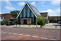
1
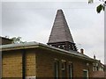
Church Tower at Marshalswick St Albans
I am still trying to ascertain what is hidden inside this unusual structure. Bell or air conditioner?
Image: © Jack Hill
Taken: 10 Apr 2003
0.05 miles
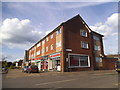
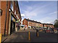
3
Shops on Sherwood Avenue, Marshalswick
Image: © David Howard
Taken: 28 May 2015
0.11 miles
4
Shops on Sherwood Avenue, Marshalswick
From Hughenden Road
Image: © David Howard
Taken: 28 May 2015
0.12 miles
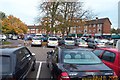
6
Quadrant centre by Sherwood Road, Marshalswick
Image: © David Howard
Taken: 28 May 2015
0.14 miles
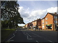
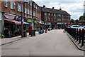
7
St Albans: The Quadrant, Marshalswick
This grid square predominantly contains housing, but The Quadrant is a busy community shopping centre for north east St. Albans. This view is taken from The Ridgeway looking north.
Image: © Nigel Cox
Taken: 18 Oct 2005
0.17 miles
9
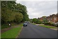
Marshal's Drive
Built on part of the original driveway for Marshalswick, a large house dating from the 18th century and demolished in 1927 at the start of the development of the area, including this road.
On the left is The Wick, a surviving area of semi-natural ancient woodland, originally called Homewood, and now a local nature reserve (see Image).
Image: © Ian Capper
Taken: 16 Sep 2011
0.18 miles
10
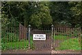
The Wick
Entrance to The Wick, a surviving area of semi-natural ancient woodland off Marshal's Drive, originally called Homewood, and now a local nature reserve. See Image for wider context and see Image for close up of the reserve sign visible to the left of the gate.
Image: © Ian Capper
Taken: 16 Sep 2011
0.18 miles