IMAGES TAKEN NEAR TO
Brampton Road, ST. ALBANS, AL1 4PY
Introduction
This page details the photographs taken nearby to Brampton Road, AL1 4PY by members of the Geograph project.
The Geograph project started in 2005 with the aim of publishing, organising and preserving representative images for every square kilometre of Great Britain, Ireland and the Isle of Man.

There are currently over 7.5m images from over14,400 individuals and you can help contribute to the project by visiting https://www.geograph.org.uk
Image Map
Images are licensed for reuse under creativecommons.org/licenses/by-sa/2.0
Notes
- Clicking on the map will re-center to the selected point.
- The higher the marker number, the further away the image location is from the centre of the postcode.
Image Listing (27 Images Found)
Images are licensed for reuse under creativecommons.org/licenses/by-sa/2.0
Image
Details
Distance
2
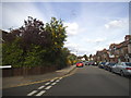
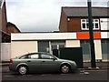
Burnham Road
Terraced housing built in 1899.
Image: © Ian Capper
Taken: 20 Apr 2013
0.04 miles
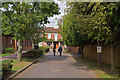
3
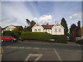
Woodstock Road North, Fleetville
At the end of Brampton Road
Image: © David Howard
Taken: 28 May 2015
0.06 miles
4

Fleetville Community Centre
Well used community centre in Royal Road.
Image: © Ian Capper
Taken: 20 Apr 2013
0.10 miles
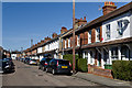
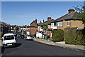
5
Eaton Road
Late Victorian/early 20th century terraced housing.
Image: © Ian Capper
Taken: 20 Apr 2013
0.10 miles
6
Local mosque
As viewed from the opposite side of Hatfield Road
Image: © Year 4
Taken: 11 Jan 2016
0.14 miles
7
Verulam School
A secondary school for boys, with a mixed sixth form. Founded in 1938, it was for many years the local boys' grammar school, being renamed Verulam School on turning comprehensive in 1975.
Image: © Ian Capper
Taken: 4 Oct 2011
0.14 miles
8
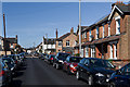
Salisbury Avenue
A stub of Salisbury Avenue where it merges into Eaton Road. Eaton Road consists of late Victorian, early 20th century terraced housing - the exception is nos 17/19, the building on the right of the road in the centre of the photo, with the tall chimney, which was destroyed in an air raid in the Autumn of 1940 and was later rebuilt. Old maps show a sharp edge to development that point, with the semi detached and detached houses of Salisbury Avenue being built in the late 1920s or 1930s.
Image: © Ian Capper
Taken: 20 Apr 2013
0.14 miles
9
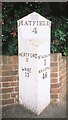
Old Milepost by the A1057, Hatfield Road, St Albans Parish
Cast iron post by the A1057, in parish of ST ALBANS (ST ALBANS District), Hatfield Road, at junction with Royal Road, in pavement, on North side of road. Wilder gabled iron casting, erected by the Reading & Hatfield turnpike trust in the 19th century.
Inscription reads:-
: HERTFORD / 11 / WARE / 13 : : HATFIELD / 4 : : ST. ALBANS / 1 / READING / 46 :
Grade II Listed. List Entry Number: 1103008
https://historicengland.org.uk/listing/the-list/list-entry/1103008
Milestone Society National ID: HE_RGHT46.
Image: © MW Hallett
Taken: 23 Mar 2003
0.15 miles
10
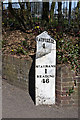
Milepost, Hatfield Road
Close up of the cast iron milepost in Fleetville (see Image).
Modern roads do not give an obvious reason for showing Hatfield and Reading as destinations on the same post, but the explanation is historical.
It is said that the Marquis of Salisbury, who lived at Hatfield House, wanted a route to the Great West Road avoiding central London, for onward travel to the spa towns of Bath and Cheltenham where, as a sufferer of gout, he habitually took the waters. He with others (including the Earl of Essex, who suffered from a similar affliction, and who lived at Cassiobury House near Watford) therefore sponsored an Act of Parliament passed in 1757 for the building of a road from Hatfield to Reading, with the Reading and Hatfield Turnpike Trust set up by a further Act passed in 1768, to improve the route between the two towns so he could be spared the discomfort and congestion of London's cobbled streets. It ran via St Albans, Watford, Rickmansworth, Amersham, High Wycombe and Marlow, with two alternative routes from there, one to Knowl Hill (on the Great West Road between Maidenhead and Reading) and the other to Reading itself via Henley-on-Thames. The Trust lasted until 1881, and at the latter date was one of the last surviving Turnpike Trusts in the country. For many years the route was known as the Gout Track, given its reputed raison-d'etre.
Ignoring short sections of other modern day road numbers and stretches where the original has now been bypassed, its route is now represented by the current A1057, A412 and A404 (and A4155 for the alternative route via Henley-on-Thames).
The original mile markers were milestones but the lettering quickly eroded and as a result they were replaced in around 1820 by new mileposts made of cast iron by Wilders & Sons of Reading, as here.
Grade II listed - for listing particulars see www.historicengland.org.uk/listing/the-list/list-entry/1103008.
Image: © Ian Capper
Taken: 20 Apr 2013
0.15 miles