Milepost, Hatfield Road
Introduction
The photograph on this page of Milepost, Hatfield Road by Ian Capper as part of the Geograph project.
The Geograph project started in 2005 with the aim of publishing, organising and preserving representative images for every square kilometre of Great Britain, Ireland and the Isle of Man.

There are currently over 7.5m images from over 14,400 individuals and you can help contribute to the project by visiting https://www.geograph.org.uk
Milepost, Hatfield Road
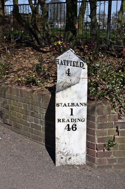
Image: © Ian Capper Taken: 20 Apr 2013
Close up of the cast iron milepost in Fleetville (see Image). Modern roads do not give an obvious reason for showing Hatfield and Reading as destinations on the same post, but the explanation is historical. It is said that the Marquis of Salisbury, who lived at Hatfield House, wanted a route to the Great West Road avoiding central London, for onward travel to the spa towns of Bath and Cheltenham where, as a sufferer of gout, he habitually took the waters. He with others (including the Earl of Essex, who suffered from a similar affliction, and who lived at Cassiobury House near Watford) therefore sponsored an Act of Parliament passed in 1757 for the building of a road from Hatfield to Reading, with the Reading and Hatfield Turnpike Trust set up by a further Act passed in 1768, to improve the route between the two towns so he could be spared the discomfort and congestion of London's cobbled streets. It ran via St Albans, Watford, Rickmansworth, Amersham, High Wycombe and Marlow, with two alternative routes from there, one to Knowl Hill (on the Great West Road between Maidenhead and Reading) and the other to Reading itself via Henley-on-Thames. The Trust lasted until 1881, and at the latter date was one of the last surviving Turnpike Trusts in the country. For many years the route was known as the Gout Track, given its reputed raison-d'etre. Ignoring short sections of other modern day road numbers and stretches where the original has now been bypassed, its route is now represented by the current A1057, A412 and A404 (and A4155 for the alternative route via Henley-on-Thames). The original mile markers were milestones but the lettering quickly eroded and as a result they were replaced in around 1820 by new mileposts made of cast iron by Wilders & Sons of Reading, as here. Grade II listed - for listing particulars see www.historicengland.org.uk/listing/the-list/list-entry/1103008.
Images are licensed for reuse under creativecommons.org/licenses/by-sa/2.0
Image Location
Latitude
51.752057
Longitude
-0.312644