IMAGES TAKEN NEAR TO
Brampton Road, ST. ALBANS, AL1 4PS
Introduction
This page details the photographs taken nearby to Brampton Road, AL1 4PS by members of the Geograph project.
The Geograph project started in 2005 with the aim of publishing, organising and preserving representative images for every square kilometre of Great Britain, Ireland and the Isle of Man.

There are currently over 7.5m images from over14,400 individuals and you can help contribute to the project by visiting https://www.geograph.org.uk
Image Map
Images are licensed for reuse under creativecommons.org/licenses/by-sa/2.0
Notes
- Clicking on the map will re-center to the selected point.
- The higher the marker number, the further away the image location is from the centre of the postcode.
Image Listing (65 Images Found)
Images are licensed for reuse under creativecommons.org/licenses/by-sa/2.0
Image
Details
Distance
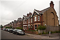
1
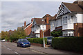
Brampton Road
A road of contrasts in the Fleetville area of St Albans. The south side (off to the right of the photo) was developed in the early 20th century with fairly high density Edwardian villas. The north side, seen here, was developed between the wars with larger detached houses.
Image: © Ian Capper
Taken: 4 Oct 2011
0.04 miles
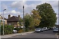
2
Verulam School
A secondary school for boys, with a mixed sixth form. Founded in 1938, it was for many years the local boys' grammar school, being renamed Verulam School on turning comprehensive in 1975.
Image: © Ian Capper
Taken: 4 Oct 2011
0.10 miles
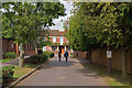
3
Blandford Road
Edwardian housing in this road off Hatfield Road, built in 1905.
Image: © Ian Capper
Taken: 26 Jun 2012
0.11 miles
4
Clarence Road
Edwardian villas built as part of the development of St Peter's Farm, itself part of the Earl Spencer's holdings in St Albans.
Image: © Ian Capper
Taken: 4 Oct 2011
0.12 miles
5
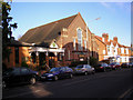
Methodist Church, Hatfield Road, St. Albans
Some two hundred yards east of its Anglican neighbour, this is an attractive church especially inside, but externally it cannot compete with the splendid Victorian gothic of St. Paul's.
Image: © Dr Neil Clifton
Taken: 16 Jan 2008
0.12 miles
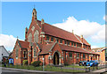
6
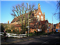
St. Paul's Church, Hatfield Road, St. Albans
Image: © Dr Neil Clifton
Taken: 16 Jan 2008
0.12 miles
8
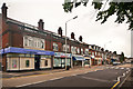
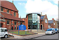
Hatfield Road
Shops in this part of St Albans developed around the turn of the 19th/20th centuries.
Image: © Ian Capper
Taken: 26 Jun 2012
0.13 miles
9
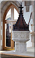
St Paul, Blandford Road, St Albans - Font
Image: © John Salmon
Taken: 14 Mar 2013
0.13 miles