IMAGES TAKEN NEAR TO
Chaucer Close, Sandridge Road, ST. ALBANS, AL1 4FJ
Introduction
This page details the photographs taken nearby to Chaucer Close, Sandridge Road, AL1 4FJ by members of the Geograph project.
The Geograph project started in 2005 with the aim of publishing, organising and preserving representative images for every square kilometre of Great Britain, Ireland and the Isle of Man.

There are currently over 7.5m images from over14,400 individuals and you can help contribute to the project by visiting https://www.geograph.org.uk
Image Map
Images are licensed for reuse under creativecommons.org/licenses/by-sa/2.0
Notes
- Clicking on the map will re-center to the selected point.
- The higher the marker number, the further away the image location is from the centre of the postcode.
Image Listing (87 Images Found)
Images are licensed for reuse under creativecommons.org/licenses/by-sa/2.0
Image
Details
Distance
1
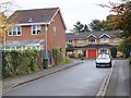
Archers Fields off Sandridge Road
A modern cul-de-sac
Image: © David Smith
Taken: 27 Oct 2011
0.05 miles
2
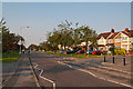
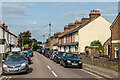
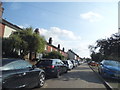
Sandridge Road
1930s housing on what was once an ancient country lane, possibly even of pre-Roman origin.
The wide open verges are historic. Known as the Sandridge Road Wastes, they are strips of common land originally used for resting and grazing animals prior to market, with the right to use them free of charge having been granted following the Peasants' Revolt in 1381. They are now managed by St Albans City Council - see Image for a sign further along the road.
The trees are flowering cherries planted in 1935 in commemoration of George V's Silver Jubilee. They make a striking display in spring when in flower, with the flowering colours being alternately red and white. These represent the colours of the Lancastrians and Yorkists in the War of the Roses, Sandridge Road and the adjacent Bernards Heath being the site of the Second Battle of St Albans in 1461.
Image: © Ian Capper
Taken: 25 Jul 2012
0.07 miles
3
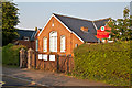
Bernards Heath Infant School
Built in 1903, this building replaced a temporary school established in 1888, serving the childeren of the "Sandridge New Town" area, between Sandridge Road and Sandpit Lane. Locally listed.
Image: © Ian Capper
Taken: 25 Jul 2012
0.07 miles
4
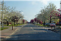
B651 Sandridge Road, St Albans
Towards Sandridge.
Image: © Robin Webster
Taken: 2 May 2021
0.07 miles
5
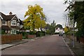
Upper Culver Road
Housing in the mainly late 19th/early 20th Century development of "Sandridge New Town", an area of land between Sandpit Lane and Sandridge Road, originally outside the boundaries of St Albans and in the parish of Sandridge, prior to the extension of the municipal area in 1879, just south of where Boundary Road was laid out. Upper Culver Road is the extension of Culver Road north of Boundary Road.
Image: © Ian Capper
Taken: 11 Sep 2020
0.09 miles
6
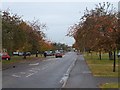
Autumn colour in Sandridge Road
The road has wide grassy edges along this stretch.
Image: © David Smith
Taken: 27 Oct 2011
0.09 miles
7
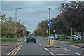
St Albans : Sandridge Road B651
Looking along Sandridge Road.
Image: © Lewis Clarke
Taken: 27 Apr 2019
0.09 miles
8
Battlefield Road
A road of large mainly detached houses, developed in the 1920s and 1930s. The name commemorates the Second Battle of St Albans in 1461, fought on nearby Bernards Heath.
Image: © Ian Capper
Taken: 16 Sep 2011
0.10 miles
9
Houses on Sandridge Road, Bernards Heath
Image: © David Howard
Taken: 22 Jul 2014
0.10 miles
10
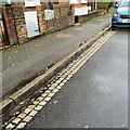
Channel, Upper Heath Road, St Albans
The three rows of stone blocks or setts forming the channel make a pleasing contrast with the tarmac: warm cream against purplish dark grey; coarse texture against fine-grained. The setts are the colour of Clunch but it seems unlikely that a form of chalk would be able to withstand wetting and the passage of vehicles.
Page 23 of the glorious Hertfordshire Strategic Stone Study from Historic England https://www2.bgs.ac.uk/mineralsuk/download/EHCountyAtlases/Hertfordshire_Building_Stone_Atlas.pdf illustrates a similar construction in St Michael's Street, St Albans. Upper Heath Road is unlikely to be different. The kerb (which could be mistaken for concrete) is identified as Sarsen Stone, probably from Buckinghamshire, and the setts as Granodiorite, an igneous rock well able to withstand wear and tear, possibly from the Newry area of County Armagh; 'Newry Granite', according to Wikipedia.
Image: © Robin Stott
Taken: 15 Nov 2022
0.10 miles