IMAGES TAKEN NEAR TO
Sandpit Lane, ST. ALBANS, AL1 4BP
Introduction
This page details the photographs taken nearby to Sandpit Lane, AL1 4BP by members of the Geograph project.
The Geograph project started in 2005 with the aim of publishing, organising and preserving representative images for every square kilometre of Great Britain, Ireland and the Isle of Man.

There are currently over 7.5m images from over14,400 individuals and you can help contribute to the project by visiting https://www.geograph.org.uk
Image Map
Images are licensed for reuse under creativecommons.org/licenses/by-sa/2.0
Notes
- Clicking on the map will re-center to the selected point.
- The higher the marker number, the further away the image location is from the centre of the postcode.
Image Listing (19 Images Found)
Images are licensed for reuse under creativecommons.org/licenses/by-sa/2.0
Image
Details
Distance
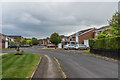
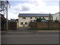
1
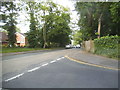
Sandpit Lane at the junction of Woodstock Road North
Image: © David Howard
Taken: 28 May 2015
0.03 miles
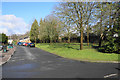
2
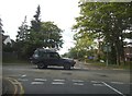
Sandpit Lane at the junction of Woodstock Road North
Image: © David Howard
Taken: 28 May 2015
0.03 miles
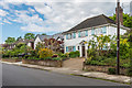
3
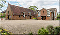
Homewood Road URC
United Reformed Church situated at the corner of Homewood Road and Sandpit Lane.
Originally a Presbyterian Church, before the formation of the URC in 1972, meetings started here in 1950, with the present building opened in 1964 and extended in 1990.
Image: © Ian Capper
Taken: 1 May 2020
0.04 miles
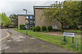
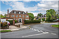
4
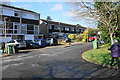
St John's Court
An outlying residential development in St Albans.
Image: © Bill Boaden
Taken: 27 Feb 2020
0.07 miles
5
Monks Horton Way
c1960s road off Sandpit Lane.
Image: © Ian Capper
Taken: 1 May 2020
0.08 miles
6
Green space at St John's Court
A planned part of the development.
Image: © Bill Boaden
Taken: 27 Feb 2020
0.09 miles
7
The Dell
c1960s apartment blocks off Sandpit Lane, built on the plot of a large house of the same name dating from around 1903.
Image: © Ian Capper
Taken: 1 May 2020
0.11 miles
8
Homewood Road
Road developed in the c1930s. The name refers to the area of woodland on which they were built, Home Wood, part of which remains as "The Wick".
Image: © Ian Capper
Taken: 1 May 2020
0.11 miles
9
Mount Carmel School, Marshalswick
It has recently been painted over the red bricks.
Image: © David Howard
Taken: 28 May 2015
0.15 miles
10
The Park
Elongated crescent of upmarket houses off Faircross Way (in the right background), shown on the 1937-9 1:2,500 laid out but undeveloped bar one house.
Image: © Ian Capper
Taken: 1 May 2020
0.16 miles