IMAGES TAKEN NEAR TO
Upper Lattimore Road, ST. ALBANS, AL1 3TU
Introduction
This page details the photographs taken nearby to Upper Lattimore Road, AL1 3TU by members of the Geograph project.
The Geograph project started in 2005 with the aim of publishing, organising and preserving representative images for every square kilometre of Great Britain, Ireland and the Isle of Man.

There are currently over 7.5m images from over14,400 individuals and you can help contribute to the project by visiting https://www.geograph.org.uk
Image Map
Images are licensed for reuse under creativecommons.org/licenses/by-sa/2.0
Notes
- Clicking on the map will re-center to the selected point.
- The higher the marker number, the further away the image location is from the centre of the postcode.
Image Listing (310 Images Found)
Images are licensed for reuse under creativecommons.org/licenses/by-sa/2.0
Image
Details
Distance
1
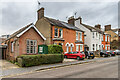
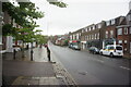
Upper Lattimore Road
Late Victorian buildings in Upper Lattimore Road. That on the left is the St Albans Quakers Meeting House, a former school room bought by the Quakers in 1912 and subsequently extended over the years.
Image: © Ian Capper
Taken: 21 Feb 2020
0.02 miles
2
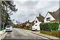
Marlborough Gate
Cul-de-sac off Upper Latimore Road, developed in 1923 on the former land of Marlborough House (see Image), following the sale of the house to Loreto College that year.
Image: © Ian Capper
Taken: 21 Feb 2020
0.02 miles
3
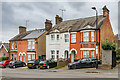
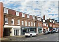
Upper Lattimore Road
Two pairs of late Victorian semi-detached houses in Upper Lattimore Road.
Image: © Ian Capper
Taken: 21 Feb 2020
0.02 miles
4
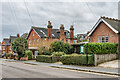
Upper Lattimore Road
Late Victorian buildings in Upper Lattimore Road. That on the right is the St Albans Quakers Meeting House, a former school room bought by the Quakers in 1912 and subsequently extended over the years.
Image: © Ian Capper
Taken: 21 Feb 2020
0.02 miles
5
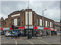
91 Victoria Street
1930s building at the junction of Victoria Street and Upper Lattimore Road, originally called Victoria Parade, now housing the outdoor wear retailer Cotswold.
Image: © Ian Capper
Taken: 17 May 2019
0.03 miles
7
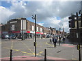
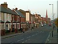
Victoria Street, St Albans
Victoria Street is a mixture of shops, houses and business premises, with a couple of pubs, a church and a station as well.
It is also most of B691, a short classified B road which runs for just one 1 km between the city centre to just past the station.
Image: © Des Blenkinsopp
Taken: 24 Aug 2024
0.04 miles
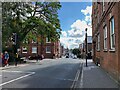
8
St Albans, Victoria Road, Lattimore/Upper Lattimore Road
Image: © Roy Hughes
Taken: 21 Apr 2012
0.04 miles
9
Victoria Street, looking east
This is the main road from the centre of the City to the railway station.
Image: © Alan Murray-Rust
Taken: 2 Nov 2015
0.04 miles
10
East on Victoria Street, St Albans
This interminable, noisy, busy street drops steeply down from the town centre then climbs steeply to cross the railway south of City station.
Photo number 7571037.
Image: © Robin Stott
Taken: 17 Aug 2023
0.04 miles