IMAGES TAKEN NEAR TO
Victoria Street, ST. ALBANS, AL1 3TE
Introduction
This page details the photographs taken nearby to Victoria Street, AL1 3TE by members of the Geograph project.
The Geograph project started in 2005 with the aim of publishing, organising and preserving representative images for every square kilometre of Great Britain, Ireland and the Isle of Man.

There are currently over 7.5m images from over14,400 individuals and you can help contribute to the project by visiting https://www.geograph.org.uk
Image Map
Images are licensed for reuse under creativecommons.org/licenses/by-sa/2.0
Notes
- Clicking on the map will re-center to the selected point.
- The higher the marker number, the further away the image location is from the centre of the postcode.
Image Listing (238 Images Found)
Images are licensed for reuse under creativecommons.org/licenses/by-sa/2.0
Image
Details
Distance
1
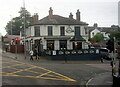
The Horn public house
On Victoria Street, St Albans.
Image: © Ian S
Taken: 18 Jun 2022
0.01 miles
2
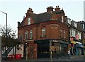
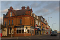
153 Victoria Street
Corner shop with unusually decorative terracotta panels at eaves level. Locally listed in the Conservation Area review.
Image: © Alan Murray-Rust
Taken: 2 Nov 2015
0.01 miles
3
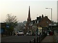
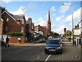
Victoria Street at twilight
Looking west from the bridge over the railway. The spire of Trinity United Reformed Church is a prominent landmark.
Image: © Alan Murray-Rust
Taken: 2 Nov 2015
0.01 miles
5
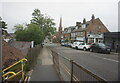
Victoria Street
A row of Edwardian shops running from the junction of Victoria Street with Beaconsfield Road (the road off to the left) to its bridge over the railway (in the background). No 145, the nearest building, has particularly fine terracotta detailing. Most are locally listed.
Image: © Ian Capper
Taken: 3 Dec 2011
0.02 miles
6
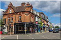
Victoria Street
Row of small shops in Victoria Street built around the turn of the 19th/20th Centuries, opposite was the original site of St Albans City Station (since replaced by a new building beyond the railway bridge in the right background, although a side entrance remains in its original location). Note the terracotta detailing on no 145, the nearest building.
Image: © Ian Capper
Taken: 11 Jul 2020
0.02 miles
7
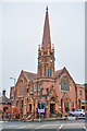
St Albans : Trinity United Reformed Church
A church on the corner of Victoria Street and Beaconsfield Road.
Image: © Lewis Clarke
Taken: 4 Oct 2018
0.02 miles
8
St Albans: Alma Road
The road is named after a battle during the Crimean War when an Anglo-French army under the command of Lord Raglan defeated a Russian army in the vicinity of the River Alma on 20 September 1854. The Victorians loved to commemorate these imperial victories and there are currently at least another 70 Alma Roads scattered through towns the length and breadth of the country. Image is prominent at the end of the road. and Image is also visible to the right.
Image: © Nigel Cox
Taken: 6 Jul 2009
0.02 miles
9
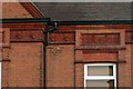
153 Victoria Street, detail
See http://www.geograph.org.uk/photo/4745601 for location.
Image: © Alan Murray-Rust
Taken: 2 Nov 2015
0.02 miles
10
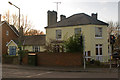
Midland Place
Former pub, now redeveloped as flats.
As a pub, it was originally called the Masons Arms. Following the arrival in 1868 of the Midland Railway, whose station was nearby, it was renamed The Midland Railway, with the reference being retained in the redevelopment. See Image for a view in 1994 when still a pub.
Locally listed.
Image: © Ian Capper
Taken: 3 Dec 2011
0.02 miles