IMAGES TAKEN NEAR TO
Bricket Road, ST. ALBANS, AL1 3JW
Introduction
This page details the photographs taken nearby to Bricket Road, AL1 3JW by members of the Geograph project.
The Geograph project started in 2005 with the aim of publishing, organising and preserving representative images for every square kilometre of Great Britain, Ireland and the Isle of Man.

There are currently over 7.5m images from over14,400 individuals and you can help contribute to the project by visiting https://www.geograph.org.uk
Image Map
Images are licensed for reuse under creativecommons.org/licenses/by-sa/2.0
Notes
- Clicking on the map will re-center to the selected point.
- The higher the marker number, the further away the image location is from the centre of the postcode.
Image Listing (463 Images Found)
Images are licensed for reuse under creativecommons.org/licenses/by-sa/2.0
Image
Details
Distance
1
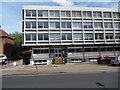
St Albans Driving Test Centre
This photo shows the DTC at Beauver House, 6 Bricket Road where car practical driving tests are carried out on weekdays. It replaced the former DTC at 21 Lattimore Road nearby somewhile ago. Two cars with L plate attachments on their roofs can be seen on the right of the photo. For SatNav purposes, the postcode of this DTC is AL1 3JX.
Image: © David Hillas
Taken: 11 Jul 2015
0.03 miles
2
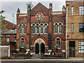
Former Tabernacle Baptist Church
The former Tabernacle Baptist Church in Victoria Street, designed by D Parkins and opened in 1882. It now houses a night club, Havana.
Image: © Ian Capper
Taken: 17 May 2019
0.04 miles
3
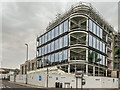
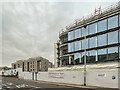
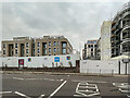
CCOS South
Large mixed use development being constructed in Victoria Street on the site of the former police station (see Image). The acronym stands for City Centre Centre Opportunity Site, and is phase 1 of a proposed redevelopment of much of the whole between St Peter's Street and Bricket Road.
Image: © Ian Capper
Taken: 21 Jul 2022
0.04 miles
4
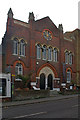
Former Tabernacle Baptist Chapel
Built in 1882 to a design of D Parkins, it is locally listed. It now houses a night club, Havana.
Image: © Ian Capper
Taken: 3 Dec 2011
0.04 miles
5
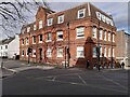
Corner of Upper Marlborough Road and Victoria Street, St Albans
The large Victorian brick building at the corner, Saxon House, is now a hotel.
Image: © A J Paxton
Taken: 9 Apr 2022
0.04 miles
6
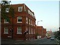
Victoria Street from Marlborough Road
The building on the left is the former hat factory of Kershaw and Co. Along with Luton, St Albans was a major location for the straw hat making industry.
There is a bench mark http://www.geograph.org.uk/photo/4745579 on the Victoria Street façade, near corner.
Image: © Alan Murray-Rust
Taken: 2 Nov 2015
0.05 miles
7
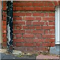
Bench Mark, 53 Victoria Street
See http://www.geograph.org.uk/photo/4745578 for location.
Image: © Alan Murray-Rust
Taken: 2 Nov 2015
0.05 miles
8
CCOS South
Large mixed use development being constructed in Victoria Street on the site of the former police station (see Image). The acronym stands for City Centre Centre Opportunity Site, and is phase 1 of a proposed redevelopment of much of the whole between St Peter's Street and Bricket Road.
Image: © Ian Capper
Taken: 21 Jul 2022
0.05 miles
9
CCOS South
Large mixed use development being constructed in Victoria Street on the site of the former police station (see Image). The acronym stands for City Centre Centre Opportunity Site, and is phase 1 of a proposed redevelopment of much of the whole between St Peter's Street and Bricket Road.
Image: © Ian Capper
Taken: 21 Jul 2022
0.05 miles
10
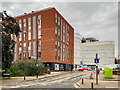
Civic Close
Looking up Civic Close, with Hertfordshire House on the left and part of the CCOS South development beyond. CCOS South is a large mixed use development being constructed in Victoria Street on the site of the former police station (see Image). The acronym stands for City Centre Centre Opportunity Site, and is phase 1 of a proposed redevelopment of much of the whole between St Peter's Street and Bricket Road.
Image: © Ian Capper
Taken: 21 Jul 2022
0.06 miles