IMAGES TAKEN NEAR TO
Alma Road, ST. ALBANS, AL1 3BP
Introduction
This page details the photographs taken nearby to Alma Road, AL1 3BP by members of the Geograph project.
The Geograph project started in 2005 with the aim of publishing, organising and preserving representative images for every square kilometre of Great Britain, Ireland and the Isle of Man.

There are currently over 7.5m images from over14,400 individuals and you can help contribute to the project by visiting https://www.geograph.org.uk
Image Map
Images are licensed for reuse under creativecommons.org/licenses/by-sa/2.0
Notes
- Clicking on the map will re-center to the selected point.
- The higher the marker number, the further away the image location is from the centre of the postcode.
Image Listing (264 Images Found)
Images are licensed for reuse under creativecommons.org/licenses/by-sa/2.0
Image
Details
Distance
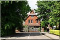
1
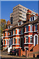
Alma Road
A terrace of locally listed Victorian villas, contrasting with St Albans' only tower block, the 1970 built Telford Court, in the background.
Image: © Ian Capper
Taken: 2 Oct 2011
0.03 miles
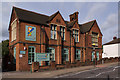
2
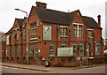
St Albans : former Board School for Girls
Built in 1882 to a design by architects John & S. Flint Clarkson.
Image: © Jim Osley
Taken: 28 Apr 2022
0.05 miles
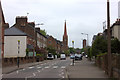
3
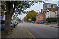
St Albans : Alma Road B6424
Looking along Alma Road.
Image: © Lewis Clarke
Taken: 4 Oct 2018
0.05 miles
4
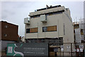
Garden Square development
Progress of this large redevelopment - compare with Image, taken a bit over two years ago at the same spot.
Image: © Robert Eva
Taken: 6 May 2017
0.06 miles
5
Playschool House
Former infants school ("St Albans School-Board Public Elementary School) built in 1882 and extended in 1890. Recently reopened as a nursery school. Locally listed.
Image: © Ian Capper
Taken: 4 Oct 2011
0.06 miles
6
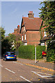
Ridgmont Road
Large Victorian villas in an area developed following the arrival of the Midland Railway at what is now St Albans City Station. They are locally listed.
Image: © Ian Capper
Taken: 2 Oct 2011
0.07 miles
8
Junction of two roads in St Albans
The roads are Ridgmont Road and Grosvenor Road.
Image: © Neil Theasby
Taken: 17 May 2014
0.07 miles
9
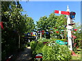
The garden of St Albans South Signal Box
St Albans South Signal Box was built in 1892 but was closed in 1980. It then became derelict but was restored from 2005 and was opened to the public in 2009. Tours include a chance to try the 44 levers. The volunteers are very knowledgeable and welcoming. The fast trains from St Pancras pass by the box and make it shake. The volunteers also maintain the garden.
For more information on the signal box see the Trust's website at http://www.tlr.ltd.uk/sigbox/home.eb
Image: © Marathon
Taken: 14 Jun 2022
0.08 miles
10
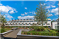
Gabriel Square
Development of 52 townhouses and 28 apartments in London Road completed in 2018 on the site of a former print works.
Image: © Ian Capper
Taken: 8 Jun 2019
0.08 miles