IMAGES TAKEN NEAR TO
Wilshere Avenue, ST. ALBANS, AL1 2PH
Introduction
This page details the photographs taken nearby to Wilshere Avenue, AL1 2PH by members of the Geograph project.
The Geograph project started in 2005 with the aim of publishing, organising and preserving representative images for every square kilometre of Great Britain, Ireland and the Isle of Man.

There are currently over 7.5m images from over14,400 individuals and you can help contribute to the project by visiting https://www.geograph.org.uk
Image Map
Images are licensed for reuse under creativecommons.org/licenses/by-sa/2.0
Notes
- Clicking on the map will re-center to the selected point.
- The higher the marker number, the further away the image location is from the centre of the postcode.
Image Listing (63 Images Found)
Images are licensed for reuse under creativecommons.org/licenses/by-sa/2.0
Image
Details
Distance
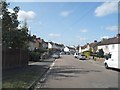
2
Mercer Row
1908s development off Wilshere Avenue. The road name commemorates Thomas Mercer Ltd, manufacturer of Chronographs and other instruments, who had a factory in nearby Eywood Road (now Griffiths Way) until the company closed in 1984.
Image: © Ian Capper
Taken: 3 Dec 2011
0.04 miles
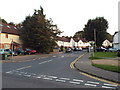
3
Doggets Way
Houses built in 1931-2, along with those in the adjacent Wilshere Avenue, by the Workman’s Housing Association to create what was then known as the Eywood estate. Beyond is the Centrium office development and in the background is St Albans Abbey.
Image: © Ian Capper
Taken: 13 Nov 2020
0.06 miles
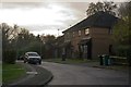
4
Doggetts Way, St Albans
Doggetts Way in a suburb of St Albans.
Image: © Malc McDonald
Taken: 26 Sep 2015
0.08 miles
5
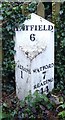
Old Milepost by the A5183, St Stephen's Hill, St Albans
Cast iron post by the A5183, in parish of ST ALBANS (ST ALBANS District), St Stephen's Hill, between Nos. 10 and 12, on the verge, on East side of road. Wilder gabled iron casting, erected by the Reading & Hatfield turnpike trust in the 19th century.
Inscription reads:-
: ST / ALBANS / 1 : : HATFIELD / 6 : : WATFORD / 7 / READING / 44 :
Grade II listed.
List Entry Number: 1103007 https://historicengland.org.uk/listing/the-list/list-entry/1103007
Milestone Society National ID: HE_RGHT44.
Image: © MW Hallett
Taken: 30 Mar 2003
0.08 miles
6
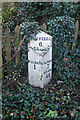
Milepost, St Stephen's Hill
Close up of the cast iron milepost seen in Image
Modern roads do not give an obvious reason for showing Hatfield and Reading as destinations on the same post, but the explanation is historical.
It is said that the Marquis of Salisbury, who lived at Hatfield House, wanted a route to the Great West Road avoiding central London, for onward travel to the spa towns of Bath and Cheltenham where, as a sufferer of gout, he habitually took the waters. He with others (including the Earl of Essex, who suffered from a similar affliction, and who lived at Cassiobury House near Watford) therefore sponsored an Act of Parliament passed in 1757 for the building of a road from Hatfield to Reading, with the Reading and Hatfield Turnpike Trust set up by a further Act passed in 1768, to improve the route between the two towns so he could be spared the discomfort and congestion of London's cobbled streets. It ran via St Albans, Watford, Rickmansworth, Amersham, High Wycombe and Marlow, with two alternative routes from there, one to Knowl Hill (on the Great West Road between Maidenhead and Reading) and the other to Reading itself via Henley-on-Thames. The Trust lasted until 1881, and at the latter date was one of the last surviving Turnpike Trusts in the country. For many years the route was known as the Gout Track, given its reputed raison-d'etre.
Ignoring short sections of other modern day road numbers and stretches where the original has now been bypassed, its route is now represented by the current A1057, A412 and A404 (and A4155 for the alternative route via Henley-on-Thames).
The original mile markers were milestones but the lettering quickly eroded and as a result they were replaced in around 1820 by new mileposts made of cast iron by Wilders & Sons of Reading, as here.
Grade II listed - for listing particulars see www.historicengland.org.uk/listing/the-list/list-entry/1103007.
Image: © Ian Capper
Taken: 3 Dec 2011
0.08 miles
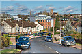
7
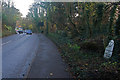
St Stephen's Hill
The A5183 (historically the A5) leading towards Holywell Hill and the centre of St Albans. For close up of the milepost on the right, see Image
Image: © Ian Capper
Taken: 3 Dec 2011
0.08 miles
8
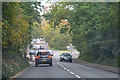
St Albans : St Stephen's Hill A5188
Heading along St Stephen's Hill.
Image: © Lewis Clarke
Taken: 4 Oct 2018
0.08 miles
9

Offices on St Stephens Hill, St Albans
Image: © David Howard
Taken: 12 Feb 2023
0.12 miles
10
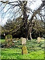
Old oak tree and cluster of graves in St Stephen's churchyard
Most of these graves date from the C18 and C19.
Image: © Bikeboy
Taken: 8 Mar 2014
0.13 miles