IMAGES TAKEN NEAR TO
Tavistock Avenue, ST. ALBANS, AL1 2NQ
Introduction
This page details the photographs taken nearby to Tavistock Avenue, AL1 2NQ by members of the Geograph project.
The Geograph project started in 2005 with the aim of publishing, organising and preserving representative images for every square kilometre of Great Britain, Ireland and the Isle of Man.

There are currently over 7.5m images from over14,400 individuals and you can help contribute to the project by visiting https://www.geograph.org.uk
Image Map
Images are licensed for reuse under creativecommons.org/licenses/by-sa/2.0
Notes
- Clicking on the map will re-center to the selected point.
- The higher the marker number, the further away the image location is from the centre of the postcode.
Image Listing (28 Images Found)
Images are licensed for reuse under creativecommons.org/licenses/by-sa/2.0
Image
Details
Distance
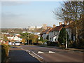
1
Doggetts Way
A telephoto view of Doggetts Way in the St Stephens area of St Albans. On the right is St Bartholomew's RC Church. In the far distance an aeroplane can be seen having just taken off from Heathrow Airport
Image: © Ian Capper
Taken: 20 Apr 2013
0.09 miles
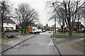
2
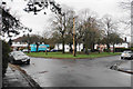
Green circle on Tavistock Avenue
A green enclave in the centre of the estate.
Image: © Bill Boaden
Taken: 28 Feb 2020
0.11 miles
3
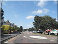
Mini-roundabout on Vesta Avenue, St Julians
Image: © David Howard
Taken: 22 Jul 2014
0.13 miles
4
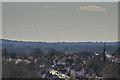
Wilshere Avenue, St Albans
The abbey dominates the skyline from all around the city. "Wilshere" is spelt right and is not named after the county!
Image: © Ray Stanton
Taken: 29 Nov 2006
0.15 miles
5
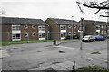
Flats on Watling View
Cordoned off by Heras fencing and presumably awaiting refurbishment.
Image: © Bill Boaden
Taken: 28 Feb 2020
0.16 miles
6
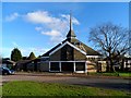
St Bartholomew's R.C. church, St Albans
Opened in 1964
Image: © Bikeboy
Taken: 19 Jan 2014
0.16 miles
7
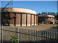
St Albans: Griffiths Way gasometers
From old Ordnance Survey maps it is evident that the site of the St Albans gas works was once much larger, stretching down to Stephen's Hill, and having its own dedicated railway siding, more or less on the site where Sainsbury's is now. These two holders are all that remains but they are large enough to warrant being individually represented on the current Ordnance Survey 1:50,000 scale mapping.
Image: © Nigel Cox
Taken: 29 May 2009
0.16 miles
8
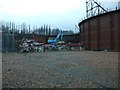
Demolition of St Albans Gasholders
The gasholders on the site of the former St Alban gasworks are now being demolished. See Image by Nigel Cox of the gasholders in 2009, having been out of use for some years and see Image for a glimpse of one holder in use in 1987.
Image: © John Webb
Taken: 5 Feb 2014
0.16 miles
9
Path onto Abbots Avenue West
The path has come from Tavistock Avenue on an adjoining estate. It is viewed on a dull wet day.
Image: © Bill Boaden
Taken: 28 Feb 2020
0.17 miles
10
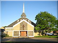
St Albans: St Bartholomew's Church in St Julians
St Bartholomew's is the Roman Catholic church serving the south side of St Albans. Its foundation stone was laid in 1962 and services commenced in 1964.
St Julians is an area in St Albans named after a former leper hospice and later a farm, which was on the west side of Watling Street, more or less opposite where the church is now.
St Albans is named after St Alban who was the first British Christian martyr, and who was beheaded around 320.
Image: © Nigel Cox
Taken: 11 May 2009
0.17 miles