IMAGES TAKEN NEAR TO
Everard Close, ST. ALBANS, AL1 2DE
Introduction
This page details the photographs taken nearby to Everard Close, AL1 2DE by members of the Geograph project.
The Geograph project started in 2005 with the aim of publishing, organising and preserving representative images for every square kilometre of Great Britain, Ireland and the Isle of Man.

There are currently over 7.5m images from over14,400 individuals and you can help contribute to the project by visiting https://www.geograph.org.uk
Image Map
Images are licensed for reuse under creativecommons.org/licenses/by-sa/2.0
Notes
- Clicking on the map will re-center to the selected point.
- The higher the marker number, the further away the image location is from the centre of the postcode.
Image Listing (65 Images Found)
Images are licensed for reuse under creativecommons.org/licenses/by-sa/2.0
Image
Details
Distance
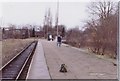
1
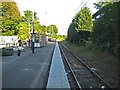
St Albans Abbey railway station
There was a discussion on Radio 4's Today programme that touched on the subject of the drabness and unappealing look of some of the country's railway stations that serve tourist attractions. The tourist attraction here is obviously the Abbey and this is the eponymous station that serves it, at the end of the Abbey Flyer branch line from Watford Junction. Network Rail would argue that the minimalist facilities are essential in maintaining the economies necessary to keep the line open.
Whatever, the station was the first in St Albans, being opened in 1858 by the London & North Western Railway some ten years before the Midland Railway built their separate main line to London through what is now St Albans City station. The railway line to Hatfield, which was completed in 1865, peeled off to the left about 400 metres away in the distance. Ordnance Survey maps of the second half of the 19th century and the first half of the 20th century show a large terminus station with a goods yard and sidings, including one to the nearby gasworks.
Under the current timetable arrangements there is a train every 45 minutes or so to Watford Junction with a scheduled journey time of 16 minutes.
Image: © Nigel Cox
Taken: 29 May 2009
0.03 miles
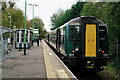
2
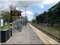
St Albans Abbey railway station
Looking south east towards Park Street
Image: © Andrew Abbott
Taken: 13 Apr 2019
0.04 miles
3
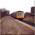
A DMU arrives at St Albans Abbey Railway Station
There had been some discussion about closing the station and line, but it remains open with regular services to Watford Junction. There was no shelter on the platform and the surroundings were very bleak. The DMU seems cobbled together and my notes tell me the destination board had Bolton on it!
Image: © nick macneill
Taken: Unknown
0.04 miles

6
St. Albans Abbey railway station, 1983
Opened in 1858 by the London and North Western Railway on its line from Watford Junction. View north west towards the buffer stops. At one time this small station boasted a canopy covering both building and track.
Image: © Nigel Thompson
Taken: 15 Jan 1983
0.04 miles
7
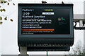
St Albans
Digital display at Abbey Station. I'm sure that the Abbey Line service will not be improved, as there is currently no passing loop between St Albans Abbey and Watford Junction.
Image: © Peter Trimming
Taken: 19 Nov 2022
0.04 miles
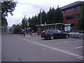
8
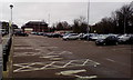
Car park of Sainsbury superstore, St Albans
Image: © David Smith
Taken: 29 Dec 2018
0.04 miles
9
St Albans
St Albans Abbey railway station. Built in 1858, the station now has a shelter but no buildings.
Image: © Peter Trimming
Taken: 19 Nov 2022
0.05 miles
10
St Albans
Abbey Station, the original railway station in St Albans, built in 1858.
Image: © Peter Trimming
Taken: 19 Nov 2022
0.05 miles