IMAGES TAKEN NEAR TO
Abbots Park, ST. ALBANS, AL1 1TW
Introduction
This page details the photographs taken nearby to Abbots Park, AL1 1TW by members of the Geograph project.
The Geograph project started in 2005 with the aim of publishing, organising and preserving representative images for every square kilometre of Great Britain, Ireland and the Isle of Man.

There are currently over 7.5m images from over14,400 individuals and you can help contribute to the project by visiting https://www.geograph.org.uk
Image Map
Images are licensed for reuse under creativecommons.org/licenses/by-sa/2.0
Notes
- Clicking on the map will re-center to the selected point.
- The higher the marker number, the further away the image location is from the centre of the postcode.
Image Listing (25 Images Found)
Images are licensed for reuse under creativecommons.org/licenses/by-sa/2.0
Image
Details
Distance
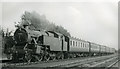
4
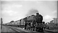
Up express on Midland Main Line south of St Albans
View NW, towards St Albans (City), Bedford and the North: St Pancras - Leicester etc. main line. The 10.40 Bradford (Forster Square) to St Pancras is headed by Stanier Class 5 No. 45253. (I was enjoying the use of a Track Permit and walked all the way from St Albans to Radlett).
Image: © Ben Brooksbank
Taken: 30 Aug 1958
0.06 miles
5
Stopping train from St Pancras approaching St Albans
View southward, towards London: ex-Midland main line, St Pancras - Leicester and the North. The 14.40 from St Pancras, running on the Slow line, is headed by post-war Fairburn variant of Stanier 4P 2-6-4T No. 42686.
Image: © Ben Brooksbank
Taken: 30 Aug 1958
0.07 miles
6
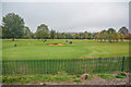
St Albans : Veralum Golf Course
A golf course seen from the railway line.
Image: © Lewis Clarke
Taken: 4 Oct 2018
0.11 miles
7
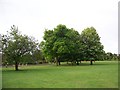
Urban Oak on Playing Field
Oak on Foxcroft playing field - one of three.
Image: © anthony helm
Taken: 10 May 2007
0.14 miles
8
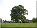
Urban Oak on Playing Field
Oak in centre of Foxcroft Playing field - one of 3
Image: © anthony helm
Taken: 10 May 2007
0.14 miles
9
Mile House Pub - development site
Over-night the Mile House Pub on London Road, St Albans, was pulled down by developers. Whilst not a listed, this building was a valued community resource in south St Albans and was open to adults and children (as it served meals). The site is currently being developed for a number of flats, hence the blue boarding. Tree have been lost as a result of this activity.
Image: © anthony helm
Taken: 27 Apr 2007
0.15 miles
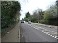
10
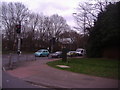
Corner of Mile House Road and London Road Sopwell
Image: © David Howard
Taken: 11 Mar 2011
0.17 miles