IMAGES TAKEN NEAR TO
Sopwell Lane, ST. ALBANS, AL1 1RS
Introduction
This page details the photographs taken nearby to Sopwell Lane, AL1 1RS by members of the Geograph project.
The Geograph project started in 2005 with the aim of publishing, organising and preserving representative images for every square kilometre of Great Britain, Ireland and the Isle of Man.

There are currently over 7.5m images from over14,400 individuals and you can help contribute to the project by visiting https://www.geograph.org.uk
Image Map
Images are licensed for reuse under creativecommons.org/licenses/by-sa/2.0
Notes
- Clicking on the map will re-center to the selected point.
- The higher the marker number, the further away the image location is from the centre of the postcode.
Image Listing (757 Images Found)
Images are licensed for reuse under creativecommons.org/licenses/by-sa/2.0
Image
Details
Distance
1
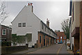
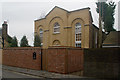
Former Inn, Sopwell Lane
St Albans' best preserved medieval Inn, situated in Sopwell Lane at its junction with Holywell Hill. Prior to the building of the current London Road by Thomas Telford in the late 18th century, Sopwell Lane and Holywell Hill were on the main coaching route into St Albans from London, as a continuation of Old London Road, and this junction turning was a key point on this route.
The building here dates from the 16th century, with records showing it in 1556 being called The Crane; later names were The Chequers and The Crown and Anchor. It is now used for housing.
Grade II* listed - see www.historicengland.org.uk/listing/the-list/list-entry/1347166 and www.historicengland.org.uk/listing/the-list/list-entry/1103095. See also Image
Image: © Ian Capper
Taken: 4 Dec 2011
0.01 miles
3
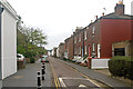
Albert Street
Originally a lane giving access to the rear of the inns of Holywell Hill and The Goat in Sopwell Lane (see Image), it was developed as a residential street in the mid 19th century. These houses are locally listed.
Image: © Ian Capper
Taken: 4 Dec 2011
0.02 miles
4
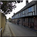
Sopwell Lane / Holywell Hill, St Albans
Former Common Lodging House, C16 long, timber framed building under
high pitched, tiled roof. Grade II* listed.
Image: © Keith Edkins
Taken: 1 Jun 2016
0.02 miles
5
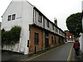
Former chapel, Sopwell Lane
A former chapel in Sopwell Lane dating from the late 18th/early 19th century. It was originally a Primitive Methodist Church and subsequently used by the Baptists as a Mission Room for Dagnall Street Baptist Church (see Image), and was marked as a Mission Hall on large scale maps from 1880 to 1924. It was subsequently used from 1934 to 2003 by the St Albans City Band as its rehearsal rooms. It has recently been restored as a house, named The Old Band Hall, in recognition of its former use. Locally listed.
Image: © Ian Capper
Taken: 4 Dec 2011
0.02 miles
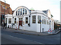
7
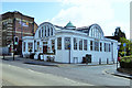
Caf? Rouge, St Albans
It looks very blanc on the outside.
Image: © Robin Webster
Taken: 14 May 2017
0.03 miles
8
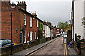
Albert Street
Originally a lane giving access to the rear of the inns of Holywell Hill and The Goat in Sopwell Lane (see Image), it was developed as a residential street in the mid 19th century. These houses are locally listed.
On the wall of the first building on the left can be seen a World War 1 Street Memorial (see Image for close up).
Image: © Ian Capper
Taken: 3 May 2012
0.03 miles
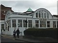
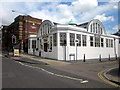
10
Caf? Rouge, Holywell Hill
A distinctive building: another contributor has researched its history as a "seed hall" in detail -see Image Listed grade 2 (list entry number 1103013).
Image: © Stephen Craven
Taken: 8 Mar 2014
0.03 miles