IMAGES TAKEN NEAR TO
Bardwell Road, ST. ALBANS, AL1 1RQ
Introduction
This page details the photographs taken nearby to Bardwell Road, AL1 1RQ by members of the Geograph project.
The Geograph project started in 2005 with the aim of publishing, organising and preserving representative images for every square kilometre of Great Britain, Ireland and the Isle of Man.

There are currently over 7.5m images from over14,400 individuals and you can help contribute to the project by visiting https://www.geograph.org.uk
Image Map
Images are licensed for reuse under creativecommons.org/licenses/by-sa/2.0
Notes
- Clicking on the map will re-center to the selected point.
- The higher the marker number, the further away the image location is from the centre of the postcode.
Image Listing (380 Images Found)
Images are licensed for reuse under creativecommons.org/licenses/by-sa/2.0
Image
Details
Distance
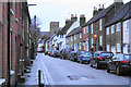
1
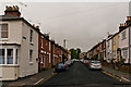
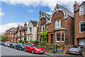
Bardwell Road
Late Victorian terrace housing. The building on the left, at its junction with Thorpe Road, is a former shop. All are locally listed.
In the wall on the left can be seen a World War 1 Street Memorial (see Image for close up).
Image: © Ian Capper
Taken: 3 May 2012
0.01 miles
2
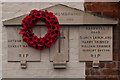
World War 1 Street Memorial, Bardwell Road
See description below. This one is in Bardwell Road, commemorating the dead of this road and neighbouring Thorpe Road. It as dedicated in June 1920.
For context see Image
Image: © Ian Capper
Taken: 3 May 2012
0.02 miles
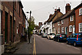
3
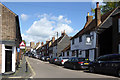
Sopwell Lane with the White Lion, St Albans
One way, leading up to Holywell Hill. The White Lion is 'reputed to be of 1594' and grade II listed, as are several other buildings up the street.
Image: © Robin Webster
Taken: 14 May 2017
0.03 miles
4
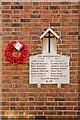
World War 1 Street Memorial, Sopwell Lane
See description below. This one is in Sopwell Lane, commemorating the dead of that street. It was dedicated in June 1920.
See Image for context.
Image: © Ian Capper
Taken: 2 Oct 2011
0.03 miles
5
Belmont Hill
Late Victorian houses in Belmont Hill.
Image: © Ian Capper
Taken: 24 Jul 2020
0.03 miles
6
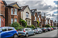
Belmont Hill
Late Victorian houses in Belmont Hill.
Image: © Ian Capper
Taken: 24 Jul 2020
0.03 miles
7
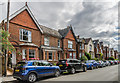
Sopwell Lane, St Albans
Nos 63-69, C16 range of 2 storeys, 2 buildings, timber framed under high pitched,
tiled roofs, with 1st floor deeply overhanging. Grade II listed. St Albans Abbey visible in the distance.
Image: © Keith Edkins
Taken: 1 Jun 2016
0.03 miles
8
Belmont Hill
Late Victorian houses in Belmont Hill.
Image: © Ian Capper
Taken: 24 Jul 2020
0.04 miles
9
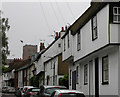
Sopwell Lane
A more historic street in St Albans.
Image: © Bill Boaden
Taken: 28 Feb 2020
0.04 miles
10
Sopwell Lane
The old route into St Albans from London, as a continuation of Old London Road, until the building of the current London Road by Thomas Telford in the late 18th century. All the buildings on the north (right hand side here) side of the road are either grade II listed or locally listed, reflecting its historic importance and its preservation as a medieval route, whilst those on the south in this photo (left hand side here) are all locally listed.
On the wall of the first building on the left can be seen a World War 1 Street Memorial (see Image for close up).
In the background is St Albans Abbey.
Image: © Ian Capper
Taken: 3 May 2012
0.04 miles