IMAGES TAKEN NEAR TO
Orchard Close, ST. ALBANS, AL1 1JP
Introduction
This page details the photographs taken nearby to Orchard Close, AL1 1JP by members of the Geograph project.
The Geograph project started in 2005 with the aim of publishing, organising and preserving representative images for every square kilometre of Great Britain, Ireland and the Isle of Man.

There are currently over 7.5m images from over14,400 individuals and you can help contribute to the project by visiting https://www.geograph.org.uk
Image Map
Images are licensed for reuse under creativecommons.org/licenses/by-sa/2.0
Notes
- Clicking on the map will re-center to the selected point.
- The higher the marker number, the further away the image location is from the centre of the postcode.
Image Listing (50 Images Found)
Images are licensed for reuse under creativecommons.org/licenses/by-sa/2.0
Image
Details
Distance
1

Alban Way
Just north of the Midland Railway bridge.
Image: © Robert Eva
Taken: 6 May 2017
0.08 miles

3
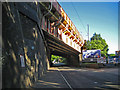
St Albans: Railway bridge over a now dismantled railway (2)
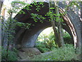
The sheer size of this massive single arch bridge has to be seen to be appreciated. It was built by the Midland Railway around 1868 to take their main line to London over the already existing Hatfield & St Albans Railway which had been completed and opened three years earlier. In 1883 the Hatfield & St Albans Railway was taken over by the Great Northern Railway, but it was a very early casualty of British Railways' days being closed to passenger traffic in 1951. Freight services lingered on until 1964. The trackbed itself is now a public path known as the Alban Way and it also forms a section of National Cycle Network Route 61. For a more distant view of the bridge please see Image
Image: © Nigel Cox
Taken: 29 May 2009
0.13 miles
4
St Albans: Railway bridge over a now dismantled railway (1)
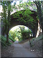
The sheer size of this massive single arch bridge has to be seen to be appreciated. It was built by the Midland Railway around 1868 to take their main line to London over the already existing Hatfield & St Albans Railway which had been completed and opened three years earlier. In 1883 the Hatfield & St Albans Railway was taken over by the Great Northern Railway, but it was a very early casualty of British Railways' days being closed to passenger traffic in 1951. Freight services lingered on until 1964. The trackbed itself is now a public path known as the Alban Way and it also forms a section of National Cycle Network Route 61. For a closer view of the bridge please see Image
Image: © Nigel Cox
Taken: 29 May 2009
0.13 miles
7
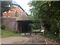
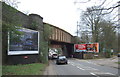
St Albans: A1081 London Road railway bridge
The bridge carries the old Midland Railway main line over London Road, formerly the A6 but now the A1081.
Image: © Nigel Cox
Taken: 29 May 2009
0.15 miles
8
Railway bridge over London Road (A1081)
Carries the Midland Main Line.
Image: © JThomas
Taken: 18 Mar 2017
0.16 miles
9

St Albans: 45 Grosvenor Road
In complete contrast to the glass-fronted Image, which is just around the corner to the left, 45 Grosvenor Road is a modern office block built out of traditional materials. Current occupiers include The Learning and Skills Council, The Trading Standards Department of Hertfordshire County Council, Fusion Insurance, Netcel, Lambert Smith Hampton, Scott & York, and Sherrards. Grosvenor Road is off to the left while the mini-roundabout is on the A1081 London Road.
Image: © Nigel Cox
Taken: 29 May 2009
0.16 miles
10

St Albans: Ziggurat (3)
A ziggurat was a stepped pyramid structure built as a temple, mostly to be found in ancient Mesopotamia. The architects of this building have used the ziggurat as a theme for this glass-fronted office block although in order to maximize the floor space area only the area above the main reception, on the left, is stepped. The building has about 8,500 square metres of office space and is at 25 Grosvenor Road, St Albans. Please see Image and Image for other views of the same building.
(It was only after downloading the image from the camera that I saw the ghostly reflection of what I assume is an aircraft vapour trail, and not an out of control Cruise missile, somewhere over Chiswell Green!)
Image: © Nigel Cox
Taken: 29 May 2009
0.18 miles