IMAGES TAKEN NEAR TO
Napsbury Lane, ST. ALBANS, AL1 1DU
Introduction
This page details the photographs taken nearby to Napsbury Lane, AL1 1DU by members of the Geograph project.
The Geograph project started in 2005 with the aim of publishing, organising and preserving representative images for every square kilometre of Great Britain, Ireland and the Isle of Man.

There are currently over 7.5m images from over14,400 individuals and you can help contribute to the project by visiting https://www.geograph.org.uk
Image Map
Images are licensed for reuse under creativecommons.org/licenses/by-sa/2.0
Notes
- Clicking on the map will re-center to the selected point.
- The higher the marker number, the further away the image location is from the centre of the postcode.
Image Listing (13 Images Found)
Images are licensed for reuse under creativecommons.org/licenses/by-sa/2.0
Image
Details
Distance
1
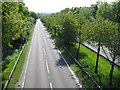
A414 North Orbital Road near St Albans
This is the eastbound carriageway viewed from the Napsbury Lane bridge, and the view in the opposite direction to Image
Image: © Nigel Cox
Taken: 10 May 2009
0.03 miles
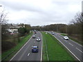
2

A414 eastbound
The bridge and slip road for the B5378.
Image: © Robin Webster
Taken: 17 Feb 2019
0.08 miles
3
North Orbital Road (A414)
Looking west from the bridge on the B5378.
Image: © JThomas
Taken: 18 Mar 2017
0.12 miles
4
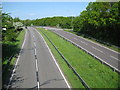
A414 North Orbital Road near St Albans
The North Orbital Road was an early precursor to the M25 Motorway and was planned in the 1920s as a road circulating around the north side of London at about a 20 mile radius of Charing Cross. It was planned to start at Colnbrook on the A4 and, skirting past Rickmansworth, St Albans, Hatfield, Hoddesdon, and Brentwood, to terminate at Tilbury, a distance of about 75 miles. In the event only sections of it got built before the Second World War intervened. Some sections of it were then planned to be incorporated into Ringway 4, the outermost of the four London ringways that were designed, but never built, in the 1970s.
This is one of the original sections of the road to the south of St Albans, viewed from the Napsbury Lane bridge. The Ordnance Survey 6" to 1 mile map of 1925 does not show it, but the 1938 Edition does, which gives a clue at to when it was built.
Image: © Nigel Cox
Taken: 10 May 2009
0.14 miles
5
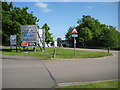
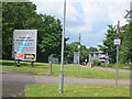
St Albans: North Orbital Commercial Park
I took this to demonstrate that Jack's Image was originally assigned to the wrong grid square Image However it is informative to compare the two images. In 2009 the same production/warehouse units are apparently still to let nearly four years on, while two more have been advertised in the interim, which demonstrates the stagnation and lack of demand in the commercial property market as much as anything else.
The North Orbital Commercial Park is off Napsbury Lane off Image
Image: © Nigel Cox
Taken: 10 May 2009
0.14 miles
6
Orbital business park, St Albans
Entry is controlled so I have no idea of the businesses.
Image: © Jack Hill
Taken: 7 Jul 2005
0.15 miles
7
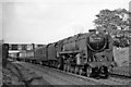
Up Empty Stock train near Napsbury
View northward, towards St Albans, Bedford and the North; ex-Midland main line, London St Pancras - Bedford - Leicester and the North. The train is being hauled by a BR Standard 9F 2-10-0 (No. 92019), which were well able to run at express speed.
Image: © Ben Brooksbank
Taken: 30 Aug 1958
0.16 miles
8
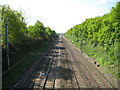
Midland Main Line Railway south of St Albans
The section between Bedford and London St Pancras was one of the last parts of the Midland Railway to be built, being completed in 1868. This is the view from the North Orbital Road bridge, with the suburban tracks on the left and the intercity lines on the right. About 600 metres down this straight section is the site of the former Napsbury station (opened in 1905 and closed to passengers in 1959) which had a siding off to the left to the former Middlesex County Mental Hospital. A link line off to the right leading to the Watford Junction to St Albans Abbey railway at Park Street was built to assist in the construction of the Midland line, but was disconnected soon after completion and never used for public traffic.
Image: © Nigel Cox
Taken: 10 May 2009
0.20 miles

10
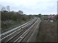
Midland Main Line
Looking north from the bridge on Napsbury Lane
Image: © JThomas
Taken: 18 Mar 2017
0.23 miles