IMAGES TAKEN NEAR TO
Aviation Avenue, HATFIELD, AL10 9UD
Introduction
This page details the photographs taken nearby to Aviation Avenue, AL10 9UD by members of the Geograph project.
The Geograph project started in 2005 with the aim of publishing, organising and preserving representative images for every square kilometre of Great Britain, Ireland and the Isle of Man.

There are currently over 7.5m images from over14,400 individuals and you can help contribute to the project by visiting https://www.geograph.org.uk
Image Map
Images are licensed for reuse under creativecommons.org/licenses/by-sa/2.0
Notes
- Clicking on the map will re-center to the selected point.
- The higher the marker number, the further away the image location is from the centre of the postcode.
Image Listing (33 Images Found)
Images are licensed for reuse under creativecommons.org/licenses/by-sa/2.0
Image
Details
Distance
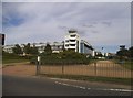
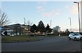
2
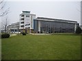
Next Generation Club
The Control Tower and Hangar are Grade II listed buildings and were formerly the Flight Test Hangar, Offices, Fire Station and Control Tower of British Aerospace.
Now converted into a Health and Fitness Club and Hotel.
http://www.controltowers.co.uk/H-K/Hatfield.htm
Image: © Rob Taylor
Taken: 23 Jan 2006
0.08 miles
3
David Lloyd leisure centre on Mosquito Way
Image: © David Howard
Taken: 6 Aug 2015
0.10 miles
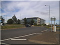
4

Hatfield Business Park
One of the office buildings in Bishop Square.
Image: © Nigel Cox
Taken: 24 Jul 2006
0.11 miles
5
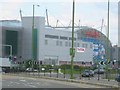
The Galleria at Hatfield
This shopping Mall sits above the A1(M) motorway and is devoted to cut price "outlet" articles such as clothing and sports goods.
Image: © Jack Hill
Taken: 7 Aug 2005
0.11 miles
6

Hatfield Business Park
The rear of the office buildings in Bishop's Square from across the lake.
Image: © Nigel Cox
Taken: 24 Jul 2006
0.19 miles
7
Fun Junction
A phantom highway planning aspirant has decided to replicate the M25/ M23 interchange in Salisbury Village. I blame TQ3053 for putting the idea in this young head
Image: © Andrew Pinder
Taken: 11 Apr 2017
0.20 miles
10
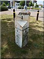
Old Milepost by the A1057, St Albans Road West
Cast iron post by the A1057, in parish of HATFIELD (WELWYN HATFIELD District), St Albans Road West, off Comet Island, West of Comet PH, on wide well kept grass verge, on North side of road. Wilder gabled iron casting, erected by the Reading & Hatfield turnpike trust in the 19th century. Broken.
Inscription reads:-
: HERTFORD / 8 ½ / WARE / 10½ : : (HA)TFIELD / 1 : : ST. ALBANS / 4 / READING / 49 :
Maker:-
: WILDER & SONS / READING :
Grade II listed.
List Entry Number: 1100903 https://historicengland.org.uk/listing/the-list/list-entry/1100903
Milestone Society National ID: HE_RGHT49.
Image: © A Rosevear
Taken: 11 Sep 2001
0.21 miles