IMAGES TAKEN NEAR TO
Bramble Road, HATFIELD, AL10 9SD
Introduction
This page details the photographs taken nearby to Bramble Road, AL10 9SD by members of the Geograph project.
The Geograph project started in 2005 with the aim of publishing, organising and preserving representative images for every square kilometre of Great Britain, Ireland and the Isle of Man.

There are currently over 7.5m images from over14,400 individuals and you can help contribute to the project by visiting https://www.geograph.org.uk
Image Map
Images are licensed for reuse under creativecommons.org/licenses/by-sa/2.0
Notes
- Clicking on the map will re-center to the selected point.
- The higher the marker number, the further away the image location is from the centre of the postcode.
Image Listing (9 Images Found)
Images are licensed for reuse under creativecommons.org/licenses/by-sa/2.0
Image
Details
Distance
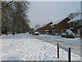
3
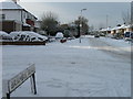
Poplar Avenue, Ellenbrook
This road could be anywhere in the outer London suburbs as well as a remote corner of Hatfield.
Image: © David Howard
Taken: 11 Apr 2013
0.07 miles
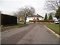
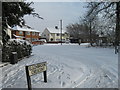
5
Great Nast Hyde House, Wilkin's Green
This is an early 17th century house, grade II listed.
Image: © David Howard
Taken: 11 Apr 2013
0.19 miles
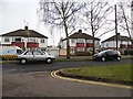
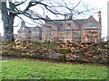
8
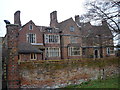
Great Nast Hyde House
Wilkins Green Lane. It is an early 17th Century brick mansion. A Grade II listed building.
Even the wall surrounding the property is Grade II listed!
Image: © Rob Taylor
Taken: 23 Jan 2006
0.22 miles