IMAGES TAKEN NEAR TO
College Lane, HATFIELD, AL10 9PB
Introduction
This page details the photographs taken nearby to College Lane, AL10 9PB by members of the Geograph project.
The Geograph project started in 2005 with the aim of publishing, organising and preserving representative images for every square kilometre of Great Britain, Ireland and the Isle of Man.

There are currently over 7.5m images from over14,400 individuals and you can help contribute to the project by visiting https://www.geograph.org.uk
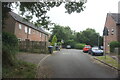
Image Map
Images are licensed for reuse under creativecommons.org/licenses/by-sa/2.0
Notes
- Clicking on the map will re-center to the selected point.
- The higher the marker number, the further away the image location is from the centre of the postcode.
Image Listing (26 Images Found)
Images are licensed for reuse under creativecommons.org/licenses/by-sa/2.0
Image
Details
Distance
4
View of construction work on the University of Hertfordshire campus from the first floor of the Film, Music and Media Building
The construction work involves a new reception block and a new library. Looking south.
Image: © Robert Lamb
Taken: 12 Oct 2013
0.12 miles
6
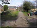
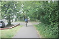
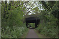
Smallford Trail part of Alban Way
Smallford Trail part of Alban Way the former route of the St Alban to Hatfield railway line passing through the house of Hillside
Image: © Shaun Ferguson
Taken: 28 Mar 2010
0.15 miles
8
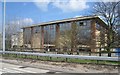
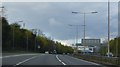
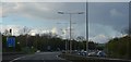
University building
University of Hertfordshire.
Image: © Mr Ignavy
Taken: 10 Apr 2010
0.18 miles