IMAGES TAKEN NEAR TO
Manor Road, HATFIELD, AL10 9BJ
Introduction
This page details the photographs taken nearby to Manor Road, AL10 9BJ by members of the Geograph project.
The Geograph project started in 2005 with the aim of publishing, organising and preserving representative images for every square kilometre of Great Britain, Ireland and the Isle of Man.

There are currently over 7.5m images from over14,400 individuals and you can help contribute to the project by visiting https://www.geograph.org.uk
Image Map
Images are licensed for reuse under creativecommons.org/licenses/by-sa/2.0
Notes
- Clicking on the map will re-center to the selected point.
- The higher the marker number, the further away the image location is from the centre of the postcode.
Image Listing (3 Images Found)
Images are licensed for reuse under creativecommons.org/licenses/by-sa/2.0
Image
Details
Distance
1
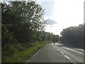
Frobisher Way
Frobisher Way Hatfield Business Park
Image: © Shaun Ferguson
Taken: 28 Mar 2010
0.14 miles
2
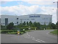
Computacenter at Hatfield Business Park
This is one of a large number of buildings now sited on the old airfield and surrounding land
Image: © Jack Hill
Taken: 7 Aug 2005
0.16 miles