IMAGES TAKEN NEAR TO
Northdown Road, HATFIELD, AL10 8SL
Introduction
This page details the photographs taken nearby to Northdown Road, AL10 8SL by members of the Geograph project.
The Geograph project started in 2005 with the aim of publishing, organising and preserving representative images for every square kilometre of Great Britain, Ireland and the Isle of Man.

There are currently over 7.5m images from over14,400 individuals and you can help contribute to the project by visiting https://www.geograph.org.uk
Image Map
Images are licensed for reuse under creativecommons.org/licenses/by-sa/2.0
Notes
- Clicking on the map will re-center to the selected point.
- The higher the marker number, the further away the image location is from the centre of the postcode.
Image Listing (19 Images Found)
Images are licensed for reuse under creativecommons.org/licenses/by-sa/2.0
Image
Details
Distance
2
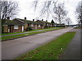
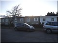
South Hatfield: The Downs
This is a view of the typical 1950s bungalows on the estate. The nearby estate roads are called The Cheviots, The Chilterns, and The Cotswolds.
Image: © Nigel Cox
Taken: 5 Jan 2007
0.07 miles
4
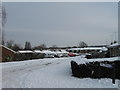
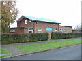
South Hatfield: The Jim McDonald Centre
This community centre was opened in 1990 and is named after Jim McDonald in recognition of his services to the community.
The dark threatening sky portended the arrival of the snowstorm that hit the area later in the day.
Image: © Nigel Cox
Taken: 28 Oct 2008
0.13 miles
5
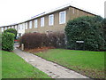
City Church Hatfield.
Hmm. Hatfield is not a city. And for a church with a name like this I would have expected it to be more centrally placed.
Image: © Robin Hall
Taken: 23 Nov 2005
0.14 miles
6
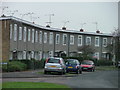
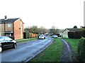
Modern terraced housing in Hatfield.
You may care to compare this with the image at this location - http://www.geograph.org.uk/photo/3383
Image: © Robin Hall
Taken: 23 Nov 2005
0.14 miles
8
South Hatfield: Grove Lea
Curved terraced housing at the western end of Grove Lea near to Bishops Rise.
Image: © Nigel Cox
Taken: 5 Jan 2007
0.15 miles
9
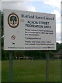
Acacia Street Recreation Area, Hatfield
Image: © Alex McGregor
Taken: 9 Jun 2011
0.16 miles
10
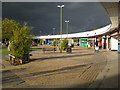
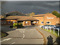
South Hatfield: High View shopping parade
The ominous dark sky portended the arrival of the unusual October snowstorm that left a couple of inches on the ground in this area later on in the day. In the meantime the High View shopping parade was basking in bright autumnal sunshine.
(From a Geograph point of view the intersection point of four grid squares, Image, Image, Image, and Image, falls just inside the shop with the bright green facings.)
Image: © Nigel Cox
Taken: 28 Oct 2008
0.17 miles