IMAGES TAKEN NEAR TO
The Pastures, HATFIELD, AL10 8PF
Introduction
This page details the photographs taken nearby to The Pastures, AL10 8PF by members of the Geograph project.
The Geograph project started in 2005 with the aim of publishing, organising and preserving representative images for every square kilometre of Great Britain, Ireland and the Isle of Man.

There are currently over 7.5m images from over14,400 individuals and you can help contribute to the project by visiting https://www.geograph.org.uk
Image Map
Images are licensed for reuse under creativecommons.org/licenses/by-sa/2.0
Notes
- Clicking on the map will re-center to the selected point.
- The higher the marker number, the further away the image location is from the centre of the postcode.
Image Listing (11 Images Found)
Images are licensed for reuse under creativecommons.org/licenses/by-sa/2.0
Image
Details
Distance
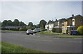
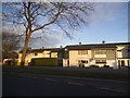
2
Honeysuckle Gardens off Oxlease Drive, Hatfield
Image: © Ian S
Taken: 19 Jun 2022
0.10 miles
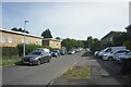
9
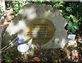
Memorial to the Hatfield Rail Tragedy
Tucked between the East Coast Main Rail Line and the A1000 The Great North Road.
Image: © Ian S
Taken: 19 Jun 2022
0.19 miles
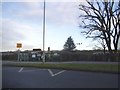
10
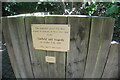
Memorial to the Hatfield Rail Tragedy
Tucked between the East Coast Main Rail Line and the A1000 The Great North Road.
Image: © Ian S
Taken: 19 Jun 2022
0.19 miles