IMAGES TAKEN NEAR TO
Howe Dell, HATFIELD, AL10 8BP
Introduction
This page details the photographs taken nearby to Howe Dell, AL10 8BP by members of the Geograph project.
The Geograph project started in 2005 with the aim of publishing, organising and preserving representative images for every square kilometre of Great Britain, Ireland and the Isle of Man.

There are currently over 7.5m images from over14,400 individuals and you can help contribute to the project by visiting https://www.geograph.org.uk
Image Map
Images are licensed for reuse under creativecommons.org/licenses/by-sa/2.0
Notes
- Clicking on the map will re-center to the selected point.
- The higher the marker number, the further away the image location is from the centre of the postcode.
Image Listing (29 Images Found)
Images are licensed for reuse under creativecommons.org/licenses/by-sa/2.0
Image
Details
Distance
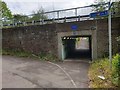
1
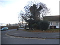
Link Drive at the junction of Old Rectory Drive
Image: © David Howard
Taken: 25 Nov 2017
0.08 miles
4
St Etheldredas Drive off French Horn Lane, Hatfield
Image: © Ian S
Taken: 19 Jun 2022
0.11 miles
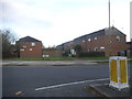
7
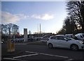
Peugeot Citroen garage on French Horn Lane, Hatfield
Image: © David Howard
Taken: 25 Nov 2017
0.16 miles
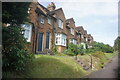
8
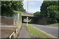
Bridge in Hatfield
Site of plaque in memory of Joseph A Gunn who died on the Titanic.
Image: © Christine Matthews
Taken: 25 Apr 2019
0.17 miles
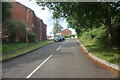
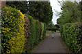
10
Church Lane at the junction of Great North Road
Image: © David Howard
Taken: 22 Jun 2019
0.18 miles