IMAGES TAKEN NEAR TO
Lockley Crescent, HATFIELD, AL10 0TL
Introduction
This page details the photographs taken nearby to Lockley Crescent, AL10 0TL by members of the Geograph project.
The Geograph project started in 2005 with the aim of publishing, organising and preserving representative images for every square kilometre of Great Britain, Ireland and the Isle of Man.

There are currently over 7.5m images from over14,400 individuals and you can help contribute to the project by visiting https://www.geograph.org.uk
Image Map
Images are licensed for reuse under creativecommons.org/licenses/by-sa/2.0
Notes
- Clicking on the map will re-center to the selected point.
- The higher the marker number, the further away the image location is from the centre of the postcode.
Image Listing (24 Images Found)
Images are licensed for reuse under creativecommons.org/licenses/by-sa/2.0
Image
Details
Distance
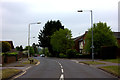
1
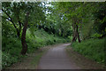
Alban Way final section at Hatfield
Looking remarkably rural although in the suburbs of Hatfield.
Image: © Robert Eva
Taken: 6 May 2017
0.08 miles
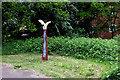
3
Artwork at the Hatfield end of the Alban Way
Image: © Robert Eva
Taken: 6 May 2017
0.13 miles
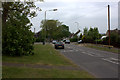
6
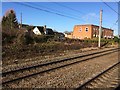
View from a Peterborough-London train - Hatfield
Image: © Nigel Thompson
Taken: 7 Feb 2017
0.16 miles
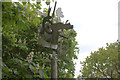
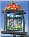
8
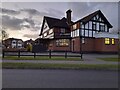
The Hopfields, Birchwood
A very typical suburban pub style.
Image: © David Howard
Taken: 10 Feb 2022
0.17 miles
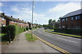
10
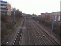
Railway lines looking towards Hatfield station
Image: © David Howard
Taken: 21 Jan 2009
0.18 miles