IMAGES TAKEN NEAR TO
Fiddle Bridge Lane, HATFIELD, AL10 0SP
Introduction
This page details the photographs taken nearby to Fiddle Bridge Lane, AL10 0SP by members of the Geograph project.
The Geograph project started in 2005 with the aim of publishing, organising and preserving representative images for every square kilometre of Great Britain, Ireland and the Isle of Man.

There are currently over 7.5m images from over14,400 individuals and you can help contribute to the project by visiting https://www.geograph.org.uk
Image Map (Loading...)


Getting Data...Please wait
Leaflet Map data © OpenStreetMap
Images are licensed for reuse under creativecommons.org/licenses/by-sa/2.0
Notes
- Clicking on the map will re-center to the selected point.
- The higher the marker number, the further away the image location is from the centre of the postcode.
Image Listing (17 Images Found)
Images are licensed for reuse under creativecommons.org/licenses/by-sa/2.0
Image
Details
Distance
1
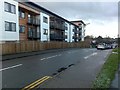
New apartments on Lemsford Road
In Roe Green, Hatfield.
Image: © David Lally
Taken: 17 Dec 2009
0.06 miles
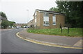
2
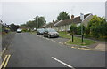
Haven Close off St Albans Road West, Hatfield
Image: © Ian S
Taken: 18 Jun 2022
0.06 miles
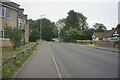
3
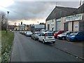
Fiddle Bridge Lane
A short lane now lined with commercial properties, both old and new.
The pub visible at the end is The Cat and Fiddle.
Image: © David Lally
Taken: 17 Dec 2009
0.06 miles
4
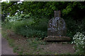
Wooden seat on the Alban Way
Made with old railway sleepers
Image: © Robert Eva
Taken: 6 May 2017
0.07 miles
5
De Havilland Close off St Albans Road West, Hatfield
Image: © Ian S
Taken: 18 Jun 2022
0.08 miles
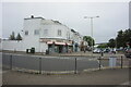

10
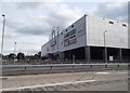
The Galleria (rear entrance), Hatfield
Image: © David Howard
Taken: 7 Sep 2017
0.20 miles