IMAGES TAKEN NEAR TO
KEITH, AB55 5QH
Introduction
This page details the photographs taken nearby to AB55 5QH by members of the Geograph project.
The Geograph project started in 2005 with the aim of publishing, organising and preserving representative images for every square kilometre of Great Britain, Ireland and the Isle of Man.

There are currently over 7.5m images from over14,400 individuals and you can help contribute to the project by visiting https://www.geograph.org.uk
Image Map
Images are licensed for reuse under creativecommons.org/licenses/by-sa/2.0
Notes
- Clicking on the map will re-center to the selected point.
- The higher the marker number, the further away the image location is from the centre of the postcode.
Image Listing (17 Images Found)
Images are licensed for reuse under creativecommons.org/licenses/by-sa/2.0
Image
Details
Distance
1
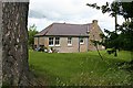
Maisley
This is not the main farm at Maisley, but a separate cottage 600 metres away. It isn't marked on the 1872 1:10,560 map, but I think it may be Maisley Cottage.
Image: © Anne Burgess
Taken: 27 Jun 2007
0.00 miles
2
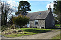
Maisley Cottage
A traditional cottage with a rather untraditional tree outside it.
Image: © Anne Burgess
Taken: 12 Mar 2021
0.00 miles
3
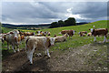
Inquisitive Cattle
When we paused to look over the gate, the cattle came over to look at us as we looked at them. Their ear tags bore not only their number, but also their names.
Image: © Anne Burgess
Taken: 21 Jul 2020
0.07 miles
4
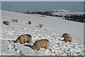
Digging for Dinner
Sheep with their heads well down in the snow, digging to reach grass on which to graze. Knock Hill dominates the skyline in the distance.
Image: © Anne Burgess
Taken: 13 Feb 2009
0.09 miles
5
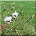
Prickly Sow-thistle (Sonchus asper)
Developing and mature seed heads on a sow-thistle.
Image: © Anne Burgess
Taken: 15 Jul 2022
0.13 miles
6
WWII Pillbox, near Keith
The Pillbox is situated overlooking a bridge taking the Keith/Dufftown road across the railway between the same 2 towns.
Image: © Christopher Gillan
Taken: 30 Apr 2006
0.15 miles
7
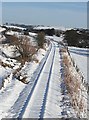
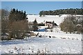
Keith to Dufftown Railway
Looking towards Keith from the overbridge at Maisley. The buildings in the middle distance are the knackery at Douglasbrae. The railway operates only in summer, as a tourist attraction, which accounts for the undisturbed snow outlining both rails and sleepers - though the slight wobble a hundred yards or so along is a bit worrying!
Image: © Anne Burgess
Taken: 13 Feb 2009
0.17 miles
8
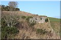
Pillbox
It seems a bit strange to find a pillbox so far from the coast, but I imagine it was for keeping watch on the nearby railway line. I didn't realise that the same pillbox has already been Geographed Image]
Image: © Anne Burgess
Taken: 14 Feb 2007
0.17 miles
9

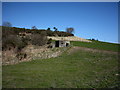
Neuk of Maisley
This house near Maisley isn't shown on the 1872 Ordnance Survey map, so presumably dates from the late 19th century. It is just above the site of the former Maisley Lime Works, which was already disused by 1872. The limeworks lay on an outcrop of Upper Dalradian limestone which can be traced from Shetland to Kintyre, and again in Ireland.
Image: © Anne Burgess
Taken: 14 Feb 2007
0.18 miles
10
Neuk of Maisley
The Keith to Dufftown railway line runs across the foreground of this view from the Bridge of Maisley. See Image] for more about the cottage.
Image: © Anne Burgess
Taken: 13 Feb 2009
0.19 miles