IMAGES TAKEN NEAR TO
Drummuir, KEITH, AB55 5JJ
Introduction
This page details the photographs taken nearby to AB55 5JJ by members of the Geograph project.
The Geograph project started in 2005 with the aim of publishing, organising and preserving representative images for every square kilometre of Great Britain, Ireland and the Isle of Man.

There are currently over 7.5m images from over14,400 individuals and you can help contribute to the project by visiting https://www.geograph.org.uk
Image Map
Images are licensed for reuse under creativecommons.org/licenses/by-sa/2.0
Notes
- Clicking on the map will re-center to the selected point.
- The higher the marker number, the further away the image location is from the centre of the postcode.
Image Listing (5 Images Found)
Images are licensed for reuse under creativecommons.org/licenses/by-sa/2.0
Image
Details
Distance
1
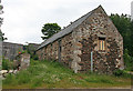
Cotterton Steading
This is the east range of the old steading at Cotterton. The windows suggest that it might perhaps have been a house at some point.
Image: © Anne Burgess
Taken: 6 Jul 2012
0.16 miles
2
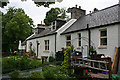
Cotterton
Cotterton is a common name for rows of farm cottages like these. Originally they would have been more or less tied cottages for married farm workers and their families.
Image: © Anne Burgess
Taken: 6 Jul 2012
0.16 miles
3
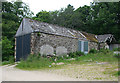
Steading at Cotterton
There is a large steading at Cotterton with two long ranges. This is the west range, evidently much altered since it was built.
Image: © Anne Burgess
Taken: 6 Jul 2012
0.18 miles
4
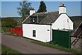
Tenanton
A smartly whitewashed farm cottage above Drummuir.
Image: © Anne Burgess
Taken: 27 Apr 2007
0.19 miles
5
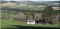
Tenanton
The occupants of the cottage at Tenanton should enjoy this fine view across Strath Isla.
Image: © Anne Burgess
Taken: 27 Apr 2007
0.19 miles